Explainer: Hurricanes, cyclones and typhoons
Here’s how the storms form and why they are so dangerous
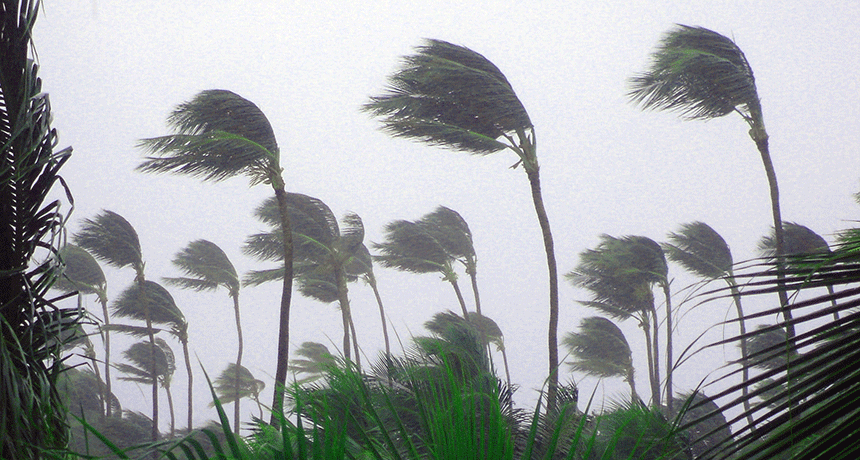
Whether called a cyclone, hurricane or typhoon, these storms bring strong winds and plenty of precipitation.
RamonBerk/istockphoto
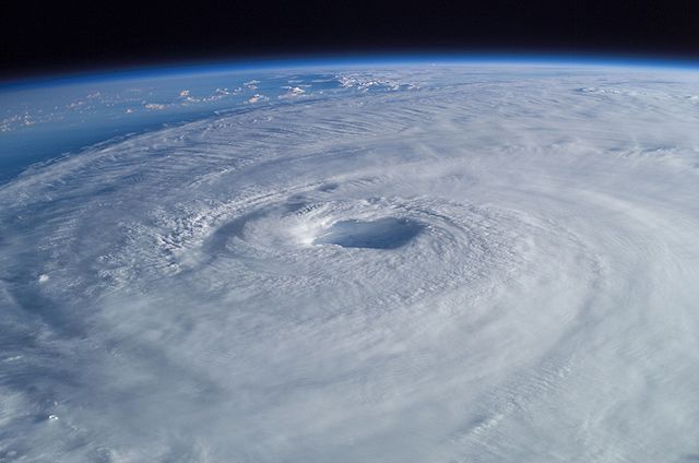
A tropical cyclone is one of the most destructive natural forces on Earth. These enormous, swirling storm systems form over the ocean. Tropical cyclones in the Atlantic Ocean or Eastern Pacific are known as hurricanes. Those in the Western Pacific are known as typhoons. When such storms erupt in the Indian Ocean, they’re referred to as cyclones.
Whatever you call them, these storms need several starting ingredients. First, there must be some sort of atmospheric disturbance or event. Typically, that will be a thunderstorm. Second, that disturbance has to occur over ocean water that is at least 26° Celsius (80° Fahrenheit). The air also needs to contain plenty of moisture, notes Kam-Biu Liu. He studies hurricanes at Louisiana State University in Baton Rouge.
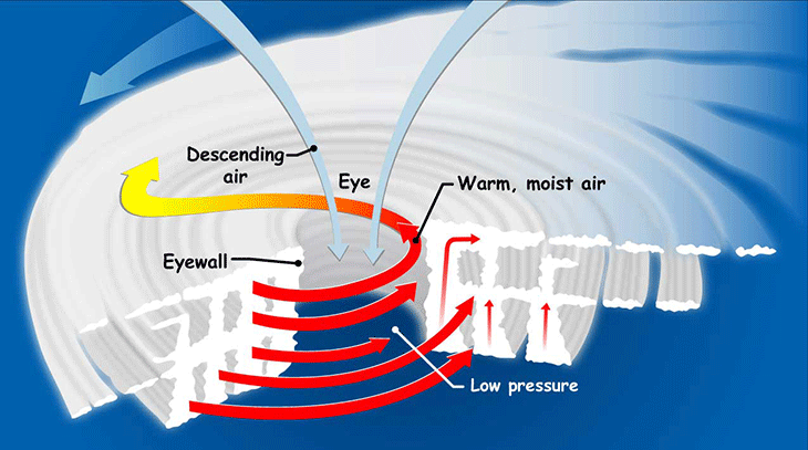
Next? As the sun warms the atmosphere, pockets of warm, humid air begin to rise from above the ocean’s surface. This temperature driven movement is known as convection. This now-water-saturated air rises into the tropopause. This is a region in the atmosphere somewhere between 9 and 17 kilometers (5.6 and 11 miles) above Earth’s surface.
As soon as the warm air gets here, it begins to cool. Cool air can’t hold as much moisture as warm air. So some of that excess water vapor condenses to form clouds and rain. This releases some heat, which warms the surrounding air. As this warm air rises, it creates regions of low air pressure beneath it.
A new parcel of air will now spin under the storm and into the space left behind by the rising warm air. This air flows in from a region of higher pressure outside the storm. It gets drawn into the center of the cyclone, the region having the lowest pressure. If the cyclone is strong enough, this center will form an “eye.” That’s a calm and cloud-free area of low pressure. A quiet zone, it sits smack dab in the middle of the raging bands of turbulence encircling it.
Together, convection and condensation drive the hurricane, explains Liu. They “create a very efficient heat engine that fuels the hurricane.”
From storm to hurricane
But swirling ocean-born storm clouds are not enough to qualify as a hurricane. The critical issue is wind speed.
As a storm strengthens, its circulating winds will become more powerful. As long as the winds’ sustained speed does not exceed 61 kilometers (38 miles) per hour, this storm will be known as a tropical depression. If its winds continue to build, attaining 62 to 117 kilometers (39 to 73 miles) per hour, it will formally become a tropical storm. At this point, it will receive an official name — such as Katrina (2005 in the Gulf of Mexico), Nepartak (2016 in China and Taiwan), Roanu (2016 in the Bay of Bengal) or Harvey (2017 in the Gulf of Mexico).
Finally, if conditions are right, the storm can intensify into a hurricane (or typhoon or cyclone, depending on its location). These intense circulating storms are rated category 1 to 5 on the Saffir-Simpson Hurricane Wind Scale. That rating reflects the maximum sustained wind speed (as measured over a 2 minute period).
Category 1 storms range from 119 to 153 kilometers per hour (74 to 95 miles per hour). Such winds can rip shingles off of houses and snap tree branches. The damage frequently is bad enough to knock out electric power for up to a few days.
A Category 2 storm will have sustained winds of 153 to 177 kph (96 to 110 mph). Winds this strong can rip siding off of buildings and uproot trees. Associated power outages can last more than a week.
A Category 3 storm slams a region with 178 to 208 kph (111 to 129 mph) winds. Category 3 and higher tropical cyclones are classified as major hurricanes. These can unleash enough damage to knock out power and water for weeks. Superstorm Sandy was, at its strongest, a category 3 hurricane. It weakened to below true hurricane status by the time it came ashore in New York and New Jersey. Still, it was devastating enough to cripple large swaths of coastal communities there.
A Category 4 storm’s sustained winds run from 209 to 251 kph (130 to 156 mph). That’s enough to flatten homes or rip through them, rendering whole communities uninhabitable. Hurricane Opal, a category 4 storm, ravaged the Florida Panhandle in 1995.
Category 5 storms are the most powerful of all. Their catastrophic winds lash a region at speeds of 252 kph (157 mph) or higher. They can unleash such extensive destruction that people may not be able to return to their homes for months. At its strongest, Hurricane Katrina reached category 5 status. It flooded whole sections of New Orleans, La., and devastated the U.S. Gulf Coast.
Tropical cyclones travel, often creating havoc far from the warm waters that first spawned them. Some may move hundreds to thousands of kilometers (or miles) across open oceans. Along that path, they may strengthen or weaken several times. Especially dangerous are storms that “make landfall.” This refers to their having crossed some island or coastline. Most hurricanes lose steam within a day or two of making landfall.
Why hurricanes are dangerous
Hurricanes are defined by their winds. And those winds unquestionably pose a major threat to coastal communities. Steady winds and even higher gusts can blow down electric-power lines, upend trees, and toss debris through the air. Whole buildings can be knocked down. The gusting, gale-force tempests can even transform branches and other types of debris into potentially deadly projectiles.
But storm dangers are not due solely to the speed at which hurricanes blow.
One of the greatest dangers that these storms pose to coastal areas is what’s known as a storm surge. As a tropical cyclone spins toward land, its winds can push seawater ashore. This may temporarily flood the land to depths of 1 to 4 meters (3 to 13 feet) or more. A storm surge can be especially dangerous if it coincides with high tide; this can push an even higher wall of water onshore.
Another hazard: Torrential storms may dump 25 centimeters (10 inches) or more of rain within 24 hours. These rains can fall too fast to soak into the ground, posing a risk of flash floods. This may occur inland, far from any storm surge. And these storms may trigger lightning and tornadoes, which pose their own risks.
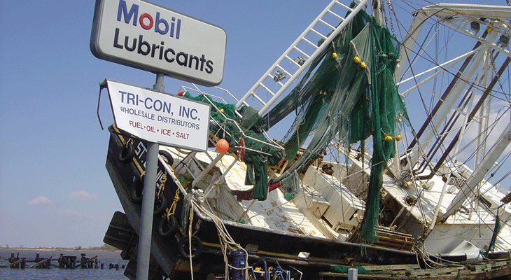
Hurricane Rita washed this shrimp boat up onto a nearby dock in 2005. Doug Helton/NOAA/Flickr (CC-BY 2.0) 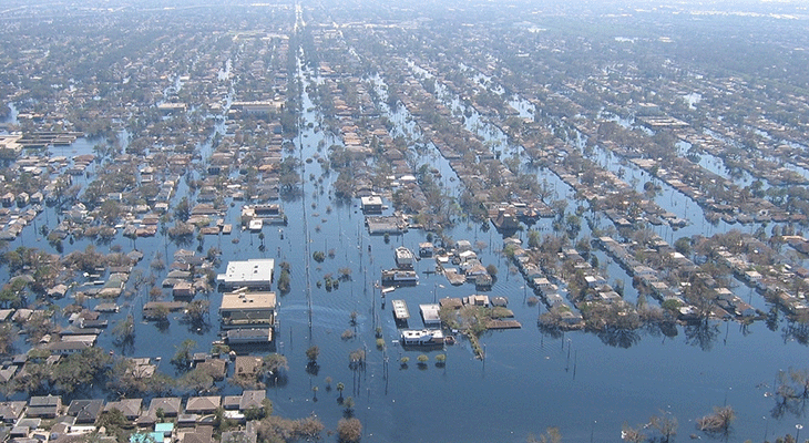
Hurricane Katrina in 2005 inundated large portions of New Orleans, La. Lieut. Commander Mark Moran/NOAA /Flickr (CC-BY 2.0) 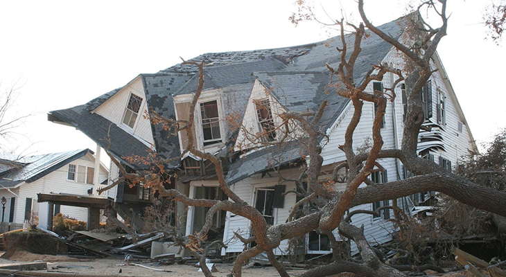
This Mississippi house collapsed during Hurricane Katrina in 2005. Barbara Ambrose/NOAA/Flickr (CC-BY 2.0) 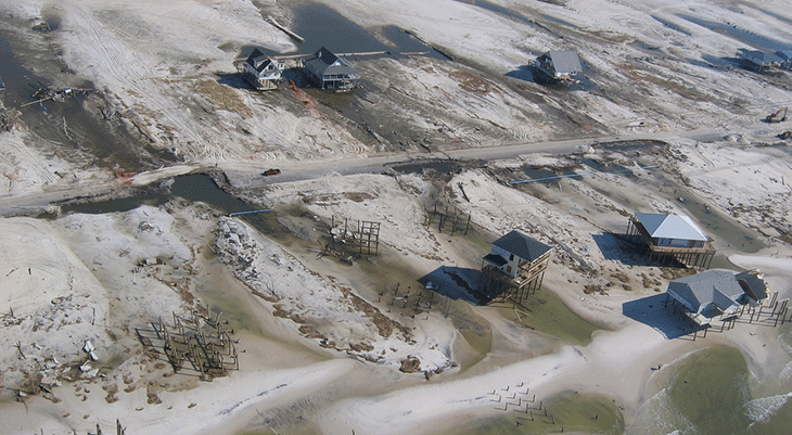
Hurricane Katrina swept away many homes that had been here, on Dauphin Island in Alabama. Lieut. Commander Mark Moran/NOAA /Flickr (CC-BY 2.0) 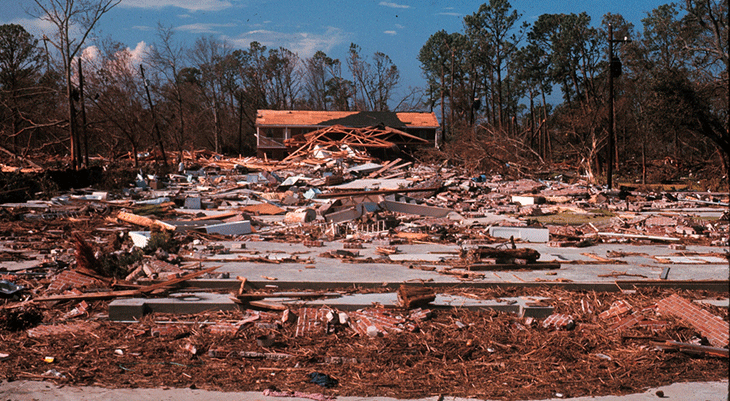
Hurricane Camille in 1969 reached category 5 and caused total devastation along a wide swath of the U.S. Gulf Coast. NOAA/Flickr (CC-BY 2.0) 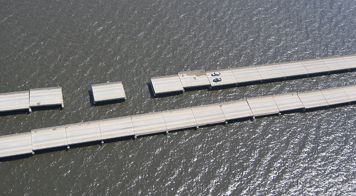
Hurricane Katrina destroyed whole spans of the I-10 roadway that ran on bridges outside New Orleans, La. Lieut. Commander Mark Moran/NOAA /Flickr (CC-BY 2.0)
Preparing for hurricane season
In the Atlantic, nearly all tropical cyclones occur between June 1 and November 30. The number of storms that form during this “hurricane season” can vary widely from year to year. In general, August and September tend to be the most at-risk months.
If you live in an area that is vulnerable to hurricanes, there are things you can do to prepare. Consider stocking up on emergency supplies. Families may want to also draw up a hurricane plan. This will include things like identifying who is supposed to take on which tasks in preparing for the storm. Part of the plan also should include identifying your closest storm shelters.
If a hurricane is headed toward your community, you might be directed to evacuate altogether. Know the best routes to get out of town. If you need to evacuate, make sure your family has a pre-packed hurricane kit. It might include batteries, cash, matches, a flashlight, first aid supplies, medications and copies of important documents.
If you aren’t advised to leave and your family decides to take shelter at home, make sure to stock up with several days’ worth of food and water. Expect that you could lose power and running water for several days. So prepare by charging all phones and other electronic devices ahead of the storm.
And help your family prepare your home. This may include covering windows and clearing yards and porches of toys, chairs or other large items that the winds could turn into dangerous missiles.


