Here’s why Irma caused some coastal water to temporarily go missing
The hurricane’s tricky behavior left some residents confused — and in danger

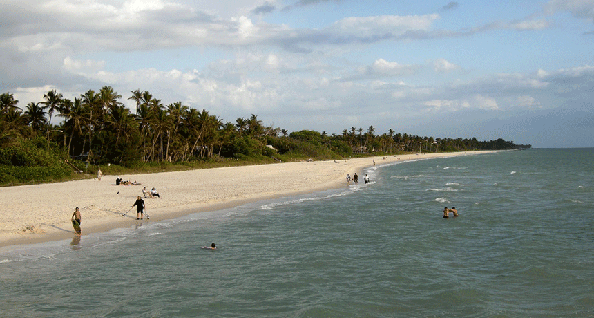
What if you were at this Naples, Fla., beach when the water suddenly got sucked back into the ocean? Earlier this month, Hurricane Irma made that happen, putting beach-goers in danger.
Milan Boers/Flickr (CC BY 2.0)
Imagine being at the beach, watching the water. All of a sudden, the ocean seems to disappear. Pretty weird, right? If that happens to you, start running — and fast. That water will come back, and maybe faster than you can outrun it. Fortunately, during Hurricane Irma the return flows did not occur at breakneck speed. But they did mystify a lot of residents.
What happened?
The coastal water left the beach, en masse. Something sucked it offshore. A tsunami will do this before it hits land. But as Hurricane Irma illustrated earlier this month, tropical cyclones also can temporarily empty a patch of coastline of its water.
The event is temporary. It’s part of a large-scale sloshing that involves enormous amounts of water. And like a pendulum, water that sloshes in one direction will invariably slosh back again. And the first sloshes may initially bring along some excess — water that had been farther out to sea.

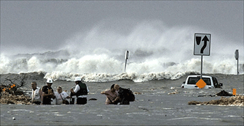
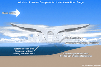
This is what’s known as storm surge. It is a damaging rise in water level that accompanies tropical cyclones as they come ashore. The water can tower to several meters (feet) above normal, crashing ashore and causing damage. When winds from a hurricane blow water toward the shore, it can collect into a surge. Sometimes, the water is blown away from the storm, only to rush back when the winds blow in the opposite direction. This is what happened at some beaches during Irma.
On Sunday, September 10, many people in Florida put themselves at unnecessary risk by watching the water’s weird behavior on the beach as Hurricane Irma was charging their way. Some played in areas normally covered by water. Others took pictures. A few people ventured out to experience the extreme winds. More still rescued animals — such manatees and fish — that had been stranded by the sudden departure of beach water.
In Florida, the beaches most affected were in Naples.
When the water finally started returning to those beaches, it didn’t seem to stop. It flowed in at a rate of 3 centimeters (1.2 inches) per minute. And it kept flowing at that rate for more than an hour. Boats, docks and moorings were all tossed around. A few sunk. Meanwhile, at nearby Naples Municipal Airport, a device used to measure air speeds — an anemometer — clocked a wind gust of 229 kilometers (142 miles) per hour. This clearly was no time to be outside.
Fortunately, no one was hurt. Part of the reason for that may be that government officials had issued stern warnings.
(Story continues below video)
The National Hurricane Center in Miami, Fla., had already issued a formal warning that the region would likely experience a storm surge. This is an abnormally high influx of water — like a super-tide — caused when persistent heavy storm winds push seawater ashore. When water along the local coastline retreated, experts at the hurricane center recognized what had happened. They knew the water would return quickly. But unless people were watching TV or listening to the radio, they might not know that they could be in trouble. So the center tapped into peoples’ cell phones.
To do this, the National Weather Service office in Miami issued a flash-flood-emergency warning. This triggered the local Emergency Alert System. It caused every cell phone in the affected area to buzz and squeal. It also alerted folks with information that a damaging storm surge was on its way.
Everyone heeded this warning. All presumably escaped to safety in time, since no deaths were reported, according to the National Weather Service.
The science behind the missing water
A few hours before Hurricane Irma struck the Florida peninsula, water began retreating from bays and inlets along a stretch of its southwest coast. Fort Myers and Naples, along the southern end of the peninsula, were hit by the phenomenon first. Then larger cities further north, such as Tampa, felt the storm’s fury. In time, some places as far away as Mobile, Ala., also experienced a mass retreat of beach water.
Curious, some daring people ventured out into the deteriorating weather. They came to gawk at the unusual spectacle. Some even walked onto the beach. (Bad idea!) All had one question: Where did the water go?

Most of the water had been sucked in toward the center of the hurricane. These storms have convergent winds, meaning that air spiraling inward is all drawn to the same place. These inward-rushing winds dragged a lot of seawater with them. This produced a bulge of water several meters (feet) high beneath the base of the storm clouds.
Hurricanes are also areas of low atmospheric pressure. Simply put: There is less air within the column of air that rises upward from the surface. Where this occurs, the total weight of a column of this air drops. With less air pushing down on the ocean, the water is able to rise up a bit more.
Imagine wearing a backpack filled with four or five heavy textbooks. Chances are that you’ll slouch over and your back will hurt. Now picture someone removing those books so that the backpack now holds only a sheet of paper. Your back will spring upwards causing you to stand tall!
The ocean also springs up this way when weather systems remove the weight above it.
As Hurricane Irma neared the coast, this storm acted as a giant sink drain. It slurped up all the water. That water had to go somewhere. Meteorologists at the National Weather Service and the National Hurricane Center alike had been scouting for dangerous conditions. They knew that as soon as Irma passed the coast and the winds switched directions, all of the water slurped out of the coastal zones would be forced back into the bays — and then some.
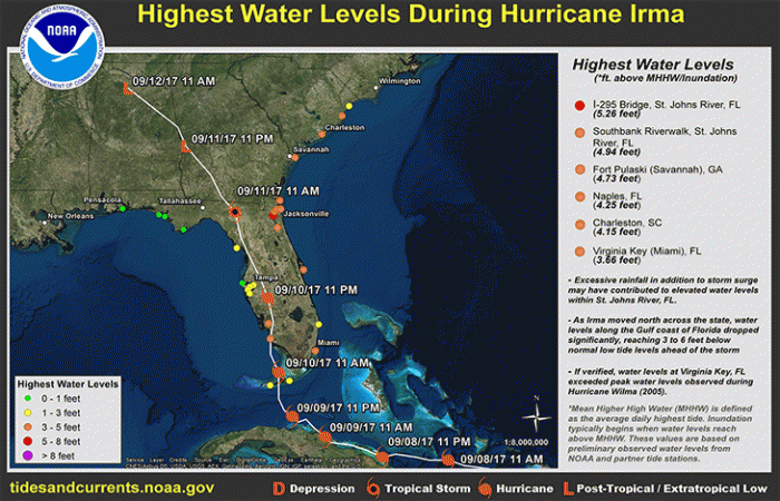
Their analyses had suggested a damaging storm surge of 0.9 to 1.8 meters (3 to 6 feet) above normal sea level could rush ashore.
In the end, the National Weather Service reported that the storm surge reached 1.83 meters (about 6 feet) in Naples. Many other regions from Florida up to South Carolina saw surges of between some 1 and 2 meters (3.28 and 6.56 feet.)
The water-shifting power of weather
This isn’t the first time that Naples has seen waters moved by the power of weather. On January 17, 2016, for instance the city experienced a rare meteotsunami (MEE-tee-oh-tzu-NAA-mee). This is where local weather conditions — ones much less severe than a hurricane — provoke a sudden jump in water levels.
Air-pressure differences can give way to seiches (SAYSH-ez). These are small, incoming walls of water. Most do little damage. They form, often in lakes or coastal fjords, in ways similar to the ripples that would develop if you blew down on a small puddle of water. They cause a sloshing forward and back again.
Meteotsunamis are like seiches on steroids.
Sometimes they have sent onto land a wall of water nearly 3 meters (9.8 feet) high. That is tall enough to roar ashore and cause serious damage. During the January 2016 episode, a line of early-morning thunderstorms came through. A tide-measuring gauge operated by the National Oceanic and Atmospheric Administration recorded that a 2.13-meter (about 7-foot) wave had crashed onto beaches. The same line of storms produced a 135 kilometer (84 mile) per hour wind gust as the storm squall blew through town. The system also spawned a few overnight tornadoes in northern Florida.
The storm surge during Irma also backed up water to roughly the same height (2.13 meters) in Jacksonville, Fla. It doesn’t take a meteotsunami to get the water to tower that high! In this case, a surge did the trick — with some help from rainfall. Rains from the storm tried to drain from a river there as the tide was rushing in. When the water couldn’t get out, it spilled over into streets, neighborhoods and homes.
Had it been a tsunami . . .
Often when coastal waters disappear suddenly, an impending tsunami is to blame. That can be catastrophic news for people living within a mile or so of the shore.
These geological events can bring a towering wall of water into coastal regions. Most are triggered by offshore or underwater earthquakes or, in exceptional cases, landslides.
As a strong earthquake shakes the ground, it produces a shock that moves as a wave of energy through the earth. If it passes through an ocean, the force of this shock wave can act almost like an oceanic form of whiplash. The affected immense blob of water now can hurtle towards shore at speeds faster than a commercial jetliner!
(Story continues below image)

Contrary to popular belief, a tsunami doesn’t usually rush ashore as one large wave. Instead, the water first drains. This reverse indicates the water is gathering into a potentially colossal offshore wave. This affected patch of seawater starts rising as it draws in water — from some inward slosh. Then the water reverses direction and begins sloshing outward again, such as back toward coastlines.
One of the strongest tsunamis in recent history struck the Indian Ocean on Christmas Day in 2004. That day, the incoming wall of water reached 9 meters (29.5 feet) above normal in places. Indonesia was especially hard hit during that event. Buildings, vehicles and even people were swept away by the waters. Coastal communities were destroyed. More than 150,000 people died.
Most weather-related coastal-water retreats tend to be relatively tamer. However, even these can, on occasion, present grave threats. So whether you’ve ever experienced a hurricane, keep in mind that weather can be dangerous both on land and at sea.
The lesson with Irma and other storm anomalies: If something in the water doesn’t feel quite right, evacuate to higher ground immediately.


