Fast sea level rise is a very recent change
New calculations show how much faster oceans have been rising in the last 20 years than in the many years before that

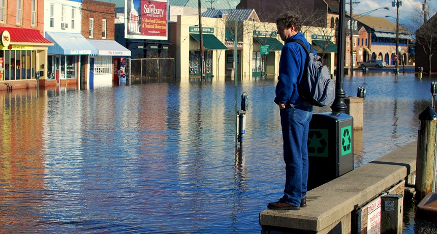
Sea levels are rising and making nuisance flooding more common in places like here, Annapolis, Md. To prepare for such events, people who live along coastlines need good predictions for how much sea levels will rise in the future.
Chesapeake Bay Program/Flickr (CC-BY-NC 2.0)
Sea levels have been rising pretty quickly over the past two decades — on average, about 3 millimeters (0.12 inch) per year. Scientists had known that this rate of rise was speeding up. But new data indicate that, compared to 25 years ago or more, those recent increases are far steeper than previously realized. That could boost how much scientists expect seas will rise in coming decades. Such information is important for people living near coastlines.
Carling Hay was on a team of scientists that released the new estimate. As a physicist, Hay studies the nature and properties of energy and matter (including water). She works at Harvard University in Cambridge, Mass.
Her team developed the new estimate by comparing historical and modern-day rates of sea level rise. They found the seas did not rise as quickly between 1901 and 1990 as scientists had thought. But the rate of rise between 1993 and 2010 does match earlier calculations.
Compared to the data on sea level rise through 1990, the more recent rate of rise is far steeper than earlier research had suggested. Hay and her colleagues did not set out to show this. Instead, they were trying to shed light on a mystery: There are two main ways to estimate sea levels, and their results have not always matched.
Throughout history, people have put out tide gauges to track sea level. These devices are like very big rulers. Placed along coastlines, they record the water’s height. The other way to calculate sea level is to figure out how much water flows into the ocean from the planet’s melting glaciers and ice sheets. This method also takes into account thermal expansion — how much cold water expands as it warms up.
Tide gauges had suggested that ocean levels were climbing 1.6 to 1.9 millimeters (0.063 to 0.075 inch) per year between 1901 and 1990. But calculations from glacial melt and thermal expansion suggested that throughout those same nine decades, seas rose a mere 1.2 millimeters per year. Though tiny, all such increases do add up. They also can cause coastal land to flood, particularly during high tides and hurricanes.
Hay and her team wanted to find out why the two sea-level-rise calculations gave such different numbers. Most scientists suspected glacial melt and thermal expansion had been underestimated. But when Hay and her team went over the numbers, they found no such problem.
So they turned their attention to the tide gauges.
And soon, they realized historic readings from tide gauges might have distorted the big picture. First, there weren’t all that many gauges. So data weren’t being collected for many regions of the world.
What’s more, most of those gauges sat along coastlines. And that’s a problem because the ocean isn’t flat and static. Waves and tides affect the sea’s height. Water can pile up in one place and dip in another. Ocean currents also have an effect. And those currents can change, depending on how close they are to land. So sea levels near coasts can be quite different from those in the open ocean. Previous research assumed sea levels in both places would roughly match.
Lastly, before 1990, most tide gauges were in the Northern Hemisphere. Ocean currents differ in the Southern Hemisphere. Also, there are fewer mountain glaciers in that part of the world. Both factors can affect sea level. Previous research didn’t take those differences into account nearly enough, says Hay.
What made the new estimates possible
Her team did assume different parts of the ocean would show different amounts of sea level rise, depending on these factors. Hay then created an algorithm to account for such factors. Algorithms are mathematical formulas that allow someone to plug in different starting numbers or conditions to answer a question.
A computer using Hay’s algorithm calculated that sea-level rise from 1901 to 1990 was about 1.2 millimeters. That brought tide gauge estimates in line with those from melting glaciers and thermal expansion. Mystery solved.
No adjustment was necessary for the average 3-millimeter-per-year sea level rise between 1993 and 2010, the algorithm showed. One reason: There were more tide gauges during this period. Moreover, scientists also started to use satellite measurements during this period. And the satellite data were quite accurate.
Stefan Rahmstorf is an expert in sea-level measurements. He works at the Potsdam Institute for Climate Impact Research in Germany. There are different ways of trying to estimate historical sea levels from incomplete data, he notes. But the important thing to realize, he says, is that all calculations now agree on one thing: that sea level has been climbing over the last two decades at the highest rate on record.
That suggests that what is driving the rise — climate change — also has increased dramatically in recent years.
Hay says her study shows it’s important to question scientific assumptions. “There are always new techniques for analyzing old data. And sometimes new data become available,” she says.


