Five portraits of Hurricane Irma’s record-breaking fury
Stunning shots display one of history’s biggest and most powerful Atlantic storms
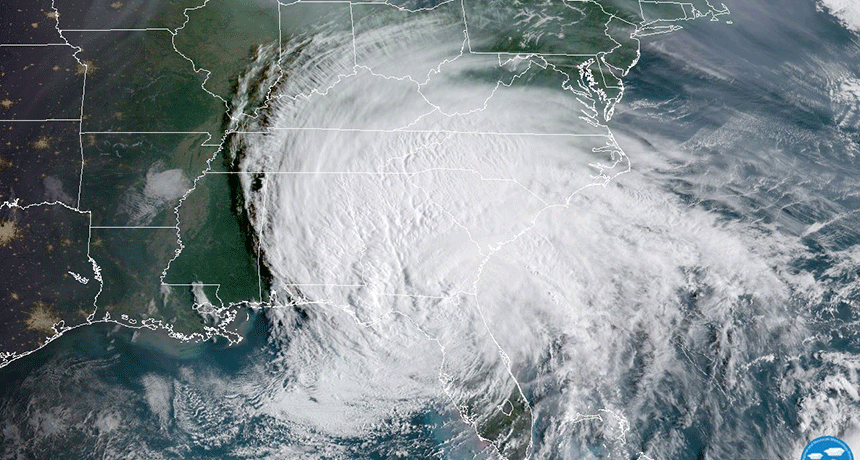
As Irma moved out of Florida (lower center), seen here at 9 a.m. Sept. 11, the massive storm now covered parts of at least 12 U.S. states and many Caribbean islands.
GOES-16/NOAA
Hurricane Irma was certainly a biggie. For much of its peak period, it spanned nearly 645 kilometers (400 miles) across. This September 2017 storm first made landfall on the Leeward Islands. Part of a submerged mountain chain, the islands mark the northeastern edge of the Caribbean Sea. And as a category 5 storm, Irma pounded these islands with winds blowing almost 300 kilometers (185 miles) per hour.
Even more impressive, 2017 is the first time on record that two hurricanes of category 4 strength or greater made landfall in the United States in the same year. After a string of lackluster hurricane seasons over the past decade, the Atlantic’s hurricane breeding ground certainly seems to be waking up. Irma was both a beautiful and terrifying sight. And these five pictures illustrate the tropical cyclone’s power.
At her dramatic peak
Hurricane Harvey, which made landfall 2 weeks before Irma, dumped more rain than any other storm to hit the continental United States. But Irma is also one for the record books. Its winds maintained their punishing peak intensity for a staggering 37 hours. That was longer than any other tropical cyclone in history — anywhere in the world.
Irma’s gusts topped 322 kilometers (200 miles) per hour close to the eye. Imagine a tornado sitting and spinning over you — for more than two hours. That’s what residents of some tiny Caribbean islands encountered when Irma stormed in at peak strength. Their only break was if the eye passed directly over them, temporarily bringing calm skies and sunshine. In the video, you can spot air spiraling into the center, and then rising up and out the middle.
At the same time, miniature swirls can be seen rotating around within the eye. These are known as mesovortices (MAY-zoh-VOR-tih-sees). Irma was one massive spinning vortex. But those smaller internal vortices commonly show up inside the strongest cyclones. And when storms like Irma spin extremely fast, smaller eddies sometimes form within the eye.
The eddies are triggered by friction. They reflect the storm’s eyewall turning at speeds far greater than that of the eye itself. The effect is similar to moving your hand through a pool of water. Because your hand is traveling faster than its surroundings, tiny whirlpools can develop along where your hand meets the water. The same was true within Irma. And the results were stunning.

In addition, wave-like undulations can be seen fanning outwards on the west (left) of Irma’s center in the video above. These are known as gravity waves. (These are not to be confused with space-borne gravitational waves. Instead, these are like waves in a pond.) They are vertical perturbations in density that spread through the atmosphere.
As winds blew toward the middle of Irma and those air masses converged, they combined and rose skyward with such speed that the rising air nearly punctured the tropopause. That’s the blanket of stable air that serves as a boundary between the two lowest layers of Earth’s atmosphere — the troposphere (where most weather occurs) and stratosphere above it. This impact sent ripples in all directions across this blanket.
Those waves were strong enough to briefly jiggle Irma’s top cloud layer (in the video). It’s somewhat like dropping a pebble into a fish pond. Wherever the pebble breaks the surface, waves will move out across the water’s surface. What can be seen in the video’s images is just a larger version of that. And instead of a rock triggering those waves, it’s the rapid rise of air in the middle crashing into the tropopause.
Irma’s eye
If you’ve ever taken a bath or watched water drain from a toilet, you’ve seen a whirlpool-like vortex develop. Place a small rubber ducky in the tub and it would start to orbit the drain. It would move slowly at first, then faster and faster as ducky nears the center and the water begin to slope inwards. That’s exactly how a hurricane works. The edges of the storm’s innermost rotating winds are the atmosphere’s equivalent to the vortex of water that ducky can ride above the tub’s drain. Owing to its size, however, the storm’s tubular eye can be kilometers across, with calm, clear skies directly above it.
The National Oceanic and Atmospheric Administration regularly dispatches aircraft to fly into hurricanes and collect data. Meteorologists aboard these Hurricane Hunter planes were able to capture a spectacular image from the calm of Irma’s eye.
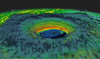
Much like water draining from the tub, air spirals into these storms at increasingly rapid speeds as it nears the center. Then the bathtub analogy breaks down because eventually that inner rotating air will rise up and out of the eyewall.
Within the eye itself, air actually sinks a bit. This suppresses the growth of clouds in the eye. That’s why the ground beneath the eye can briefly brighten with blue skies and sunlight.
A radar dome probing into the storm from Puerto Rico was able to construct a model of the same thing. It took slices of the storm clouds at sixteen levels. Then it stretched them all together in three dimensions. It’s clear from these data why airplanes were able to see clear skies in the eye. After all, there’s no storm there.
Islands stripped bare
Irma hit the eastern Caribbean islands of Virgin Gorda and Tortola with winds gusting over 275 kilometers (170 miles) per hour. An anemometer (AN-eh-MOM-eh-tur) is a device that spins with the winds and provides a readout of their speed. On the island of Barbuda, one of these devices registered a 250 kilometer (155 mile) per hour wind gust before it snapped off and blew away. These winds were strong enough to uproot trees and ravage vegetation.
And in places, they did.
(Story continues below image)
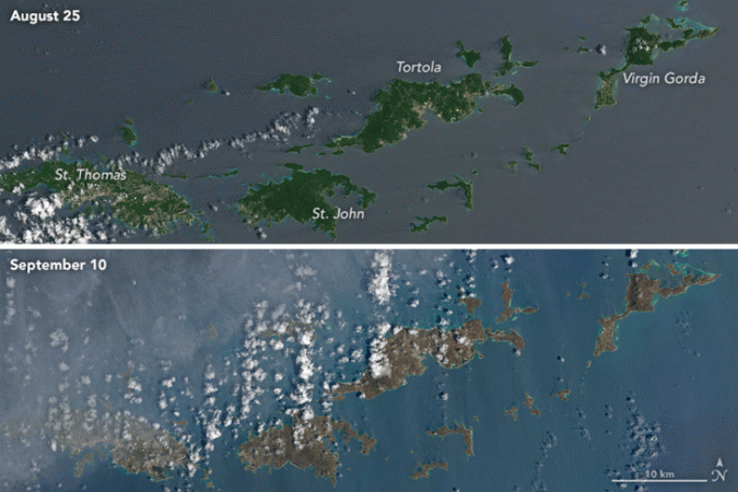
Irma scoured the landscape of several islands. With no trees, shrubs or vines left, the normally-green islands now host large swaths of bare ground. That’s why these areas now appear brown from space. All that remains is freshly churned-up earth that was left as the gale-force winds and rains carried everything else away.
In addition, a storm surge washed many tons of ocean water onto the land. This created another problem: salt spray. The wind whipped up enough sea foam to coat all the plants on several islands in a thin film of sea salt. This is harmful to plants. Given enough salt, any surviving vegetation could perish. So even trees or brush that weren’t snapped in two or shredded by the ferocious winds could soon die from the salt, scientists now fear.
A high voltage event
Few hurricanes produce lightning. The electric charge separation needed to generate an electric spark only comes about through strong updrafts in a thunderstorm. In hurricanes, the air doesn’t rise straight up as in a normal thunderstorm. Instead, it travels many kilometers sideways as it’s slowly lofted higher. This makes it very difficult for bolts of lightning to spark about.
However, plenty of lightning was spotted as Irma hovered over the island of Virgin Gorda. This is very rare behavior for such a storm, so scientists are still puzzling over what happened. However, weather radar did capture something cool that might help explain those powerful zaps.
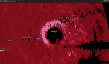
Scientists used a computer program that investigated what is known as a “specific differential phase,” or SDP. While it sounds complicated, the concept is fairly simple.
As a radar beam makes a sweep through a storm cloud, it sends out two pulses of radiation. Then it listens for the returning “echoes.” One burst of radiation goes out in horizontal pulses (sideways). The other pulse shoots out vertically-oriented (upward). By comparing the amount of energy returned, depending on the orientation of the signal, scientists can gain valuable information on the alignment of ice crystals in the storm clouds.
Most raindrops (and high up in the cloud, frozen droplets) flatten like a disk as they fall. This reflects the aerodynamic forces that make the rain or ice spread out its mass. But when a strong electric field is present, electric forces can overcome the typical aerodynamic forces. And this can cause droplets of rain or ice to orient themselves vertically (up-and-down) as they fall.
This shows up on the radar image (above) as bright colors on the western (left) side of Irma’s eye. Here, the radar’s SDP is negative, meaning that the up/down direction dominates. Under ordinary conditions, it’s physically weird for ice crystals to fall this way. That’s how scientists know that a strong electric field must have been in control. Scientists can use that information to predict lightning before the first bolt snakes out of the clouds.
Air pressure: How low can you go?
Hurricanes suck — literally. Part of what made Irma so freakishly strong was this storm’s air pressure. Air naturally flows from regions of high pressure to low pressure. It’s like how a ball will roll from a hill (a high area) to a valley (a low one). There was so much air spiraling into and up out of Irma’s center that it created what’s known as an atmospheric vacuum. This allowed the winds to race into Irma with record speed.
It also had another special effect. This atmospheric vacuum denotes an area with less air than the surrounding regions. That’s why the needle of the pressure chart (illustrated here) dropped so dramatically when the eye passed overhead. How much? By almost 10 percent. And that’s a big deal.
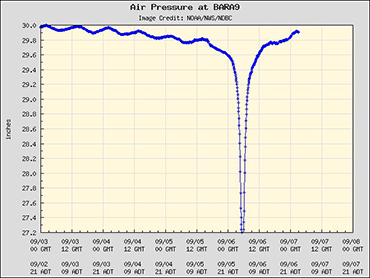
Simply put, it means that the column of air in the eye — which runs from the surface to the top of the atmosphere — weighed nearly 10 percent less than just about everywhere else on Earth. It may not sound like much, but the normal variation from clear skies to stormy weather would normally vary by less than half a percent.
This big drop in air pressure explains why some peoples’ ears popped as the eye passed overhead, similar to what happens when a person is in an airplane during takeoff or landing. And this crazy-low pressure also may have sucked out the water from their toilets (had anyone bothered to look). When the air pressure is that low, crazy things can happen!
Hurricane Irma was a powerful force of nature. With all that fury comes some telltale signs of danger on weather maps. Scientists are now studying them in hopes of gaining some great lessons for the future. Researchers will be studying data collected during Irma for quite some time. While Florida continues to pick up the pieces, one thing is clear: Always heed warnings issued during hurricanes. Take them very seriously. It just might save your life.


