Hawaii’s record 2018 rains may foretell wetter times ahead
With warmer atmospheres and oceans, monster deluges may become ever more common there and elsewhere

Residents of Hawaii have survived several major deluges this year. And scientists say a warming climate may make such record-breakers ever more common.
trendobjects/iStockphoto; adapted by L. Steenblik Hwang
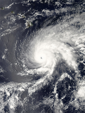
One year ago, Hurricane Harvey shattered the U.S. record for most rain to come down in a single storm. Last month, another hurricane dropped record rains, this time on Hawaii. Named Lane, its measured tally would seem to be the highest ever for this island state, and second nationally only to what Harvey unleashed on Texas.
The previous record for a tropical cyclone in Hawaii was measured at Kanalohuluhulu Ranger Station. That was during Hurricane Hiki in 1950.
The National Weather Service in Honolulu has now confirmed that Lane dropped 132.13 centimeters (52.02 inches) of rain between August 22 and 26. That total comes from an official government rain gauge on the Big Island (named Hawaii). “The previous record was 132.08 centimeters (52.00 inches),” the NWS reported in an August 27 statement. This, it concluded, shows that “Hurricane Lane has broken the Hawaii tropical cyclone storm-total rainfall record.”
However, NWS pointed out, this record will stand only “pending verification.” Confirming the feat requires a special probe. A meteorologist at the NWS forecast office said that could take months.
Why?
It’s due to how the hefty totals were measured.
NWS uses an automated “tipping bucket” rain gauge at all of its stations. The type used in Hawaii consists of a funnel that’s 30.5 centimeters (12 inches) in diameter. The funnel channels the incoming water into a bucket. That bucket tips over whenever 18.5 grams (0.65 ounce) of water collects in it. Each time the bucket tips, it registers a “click,” then adds another 0.0254 centimeter (0.01 inch) to its rainfall total.
This all seems pretty precise. But during high-end rain events, it’s not always an exact science. Sometimes, the rain comes down so fast that the bucket is constantly tipping. When this happens, the bucket can oscillate. Think of it as being a bit like a pendulum. When driven by some force, the bucket can pivot back and forth about a resting position. Here, the force is Earth’s gravity pulling on the bucket’s rainwater. The spring inside the tipping mechanism acts as a restoring force, pushing the bucket back toward its resting position.
Imagine you’re at some playground and a friend decides to ride the swing. She starts at the bottom. That’s the resting — or equilibrium — position for the swing. Now you give your friend a big push to get her going. The first few pushes are difficult as you drive the back-and-forth oscillation of the swing. But after a while, your friend swings forward, then backward, then forward and backward until each additional push requires relatively little effort. The driving force required to sustain the swing’s motion has become less.
The same thing happens in a rain gauge. As the rain falls super fast, the bucket is constantly swinging. That bucket now can become prone to tipping even when it’s not totally full. If it does, it will prematurely register a click. That will over-report the amount of rain that fell.
This will most likely occur during exceptionally heavy rains. Probing whether this likely occurred will take time.
In fact, meteorologists suspect that Hawaii’s record will stand. That’s because other stations in the area recorded similar values. And many of their rain gauges work differently. An official NWS gauge in Waiakea Uka registered 125.67 centimeters (49.48 inches). Another in Saddle Quarry saw 123.24 centimeters (48.52 inches). And a privately-owned instrument nearby was reportedly drenched with 149.35 centimeters (58.80 inches) of rain!
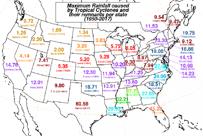
Hurricane Lane also snagged a spot as the second-biggest rain total in the United States since 1950. The only more dramatic U.S. rainmaker? Hurricane Harvey in August 2017. That storm spun for days over the greater Houston area. A rain gauge in Nederland, Texas, recorded an astonishing 153.87 centimeters (60.58 inches), just outside Houston. This storm crippled the nation’s fourth-largest city and its surrounding area.
Story continues below map.

Hills v. flatlands
Most scientists would argue that Lane and Harvey should not be compared in the same way. Among them is Eric Fisher. He’s the chief meteorologist at WBZ-TV in Boston, Mass. He has spent years forecasting weather for the entire country, and frequently appears on the CBS Evening News. “In my opinion, you can’t really compare orographic rainfall to something around sea level,” he said.
Orographic (Or-oh-GRAF-ik), he explains, refers to something that is influenced by a region’s terrain. “It’s not an even playing field,” he says.
Formed by volcanoes, the Hawaiian islands are hilly, if not downright mountainous. That means they have a lot of topographic (Tah-poh-GRAF-ik) variation — hills and valleys. That topography means the local weather may be affected by orography.
Hawaii’s hills force air uphill. That air becomes saturated by moisture as it rises. Eventually, it releases the excess as heavy rain. The windward side — the one against which the winds blow — extracts water from the air. That makes it the side on which most of the rain falls. By the time the winds have risen over the mountain, their air is now relatively dry. That’s why conditions on the far side — the leeward side — can be fairly arid (at least if the winds tend to reliably blow in the same direction).

For days, Hurricane Lane brought a steady flow of moist air onshore and up the islands’ sloped hillsides. Like a conveyer belt, this river of air brought a firehose of moisture to the Big Island. This constantly replenished moisture in the air mass. Then this air mass swept inland. The result was a period of persistent, unrelenting heavy rain.
The mountains efficiently and effectively squeezed moisture out of the soupy atmosphere. But every time the moisture was wrung out, more moisture moved in to feed the deluge.
So as impressive as Lane’s rains were, the measured totals make sense. An airport in Hilo maintains official rainfall records as well. And Lane brought it the wettest four days since recordkeeping there began in 1950.
This kind of rainfall is relatively common in mountainous regions. In fact, the town of Big Bog on the island of Maui averages 10.27 meters (33.7 feet) of rain each year. When compared to numbers that big, 132.13 centimeters (52.02 inches) over four days suddenly doesn’t sound quite so remarkable.
Harvey, in contrast, was totally unbelievable. This whopper storm unleashed catastrophic rainfall on Houston and much of the Texas Gulf Coast. Some locations picked up more than 1.5 meters (5 feet) of rain in what’s being called a once-in-a-million-year event. That storm was “unprecedented,” NWS said. It warned residents that it was so extreme that any impacts would be new and “unknown.”
Harvey’s mega-totals accumulated without the help of mountainous terrain focusing the deluge locally. Instead, Harvey’s disastrous flooding stemmed from a stalled storm system carrying an unbelievable amount of moisture.
The shape of things to come?
Both Harvey- and Lane-like downpours could become more common in the future. The reason: climate change.
Since 1970, Houston has warmed more than 1.8 degrees Celsius (3.2 degrees Fahrenheit). That warming may not sound all that large. Sure, summers will be hotter and winters milder in the future. But it is how this warming will trigger more extreme rains that could be cause for alarm.
Warmer air can hold more water. (This is a principle that scientists refer to as the Clausius-Clapeyron Relationship.) For each degree Celsius the air warms, the atmosphere can hold another 7 percent more water. So every uptick further boosts the risk of big rains and possible flooding.
Houston’s observed warming has already been linked to a disturbing rise in rainfall. Between 1980 and 2010, the city has averaged 126.42 centimeters (49.77 inches) of rain per year. But since 1970, the annual rainfall has increased by an average of 15 centimeters (6 inches).
When you look at that in terms of the size of a typical rainfall for that region, this comes to an extra 44 days of rain each year. Put another way, that area is seeing more than a month’s worth of “extra” rain each year now, thanks to climate change. And that growth in rainfall isn’t stopping.
Record rainfall events are already on the rise across the United States. Hawaii is seeing its own struggles. A different potential record was set earlier this year there. Outside the state, however, few people heard about it.
A rain gauge in Waipa, Hawaii, on the island of Kauai, recorded 126.21 centimeters (49.69 inches). It’s less than Lane’s total. But this spring downpour fell within a mere 24 hours. Because it was so extreme, this total is still being reviewed by the National Climatic Extremes Committee. If confirmed, however, it would be the nation’s highest 24-hour rainfall in history. What’s more, this record wasn’t from a tropical storm – it was just an ordinary springtime soaker.
As Earth continues to warm, destructive rains will become ever more common. Inland freshwater flooding will become a new normal. More records will break as a damper atmosphere fuels wetter storms.
And while it’s hard to attribute nearly any single event to climate change, the warning signs are here. More extreme events, a hallmark of a warming climate, are indeed emerging.


