People are changing which parts of Earth get more (or less) water
Dams, demand and climate change are shifting where this precious resource collects

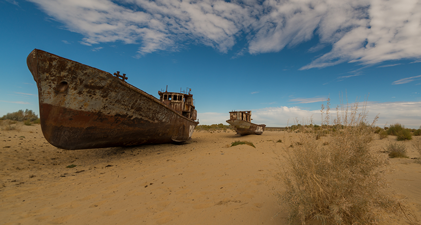
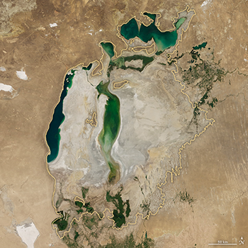
Asia’s Aral Sea, once the world’s fourth largest lake, is now largely dry. The reason: People have been pulling too much water from the rivers that feed it.
oxico/iStockphoto
Share this:
- Share via email (Opens in new window) Email
- Click to share on Facebook (Opens in new window) Facebook
- Click to share on X (Opens in new window) X
- Click to share on Pinterest (Opens in new window) Pinterest
- Click to share on Reddit (Opens in new window) Reddit
- Share to Google Classroom (Opens in new window) Google Classroom
- Click to print (Opens in new window) Print
By Sid Perkins
TOULOUSE, France — A lot of the water on Earth’s surface has shifted locales in the past few decades. That’s the finding of a surprising new study. Some lakes once thought to be permanent now exist only part of the year. Others have disappeared altogether. In still other places, new lakes and wetlands have been emerging.
Scientists sometimes refer to the depiction of Earth’s surface waters as its water “map.” At first glance, the reasons for changes in the map might seem unrelated. In fact, some sort of human activity is the root cause for many.
When people build a dam, it almost immediately begins to collect water. That change can be seen right away. But in most places, the landscape changes too slowly to notice. So it can be hard to spot a change in the map of surface waters unless you compare two time periods that are far apart, explains Luca De Felice. He’s an analyst who focuses on geospatial (GEE-oh-spay-shul) data — the types that map what’s happening across wide swaths of the globe. He works at the European Commission’s Joint Research Center in Brussels, Belgium.
De Felice looks at a lot of satellite images. For the past couple of years, he has been part of a team analyzing images taken by Landsat satellites between 1984 and 2015. The researchers focused on Earth’s lakes, rivers and other surface waters.
The task was not easy, De Felice notes. The group had more than 3 million images to review. Plus, team members had to develop software that would highlight where the water is. That’s not as simple as finding the blue stuff in an image. Microbes in lake water, for instance, might turn the water greenish. And some rivers, especially muddy ones, appear brown. That can make water difficult to distinguish from land.
To tackle the job, the team’s computers worked overtime. There were 10,000 of them working together to analyze all of those satellite photos, De Felice says. If the researchers had been running their study on just one laptop, their analysis might have taken more than 1,200 years, he estimates.
De Felice described his team’s work here, in France, on July 13. His presentation was part of a big conference known as the EuroScience Open Forum.
Mapping the changes
Over a 32-year period, the global map of Earth’s surface waters changed dramatically, the team found. Some areas where water had once been present year-round now hosts water for only part of the year. Such areas where the water cover is now temporary total some 72,000 square kilometers (27,800 square miles), De Felice reports. That’s an area a little bigger than the nation of Ireland. An even bigger share of the globe that used to be permanently wet is now dry all year long. It’s not in one spot. But all of the contributing spots together span roughly 90,000 square kilometers (34,000 square miles). That’s an area about the size of Portugal.

Consider, for example, what has happened to Central Asia’s Aral Sea. At one time, it was the world’s fourth-largest freshwater lake. Today, De Felice notes, it has largely disappeared. People have diverted a lot of water from the rivers that used to feed the lake. Much of that water is used to irrigate thirsty crops, such as cotton.
Most of the water that’s gone missing in the last three decades has disappeared from five Asian nations: Afghanistan, Kazakhstan, Uzbekistan, Iran and Iraq. (What’s left of the Aral Sea lies on the border between Kazakhstan and Uzbekistan.)
The missing water isn’t really missing, of course. It had to go somewhere. Evaporation might have sent some of it into the sky. That would have later come down elsewhere as rain and snow. Some moisture might have ended up in the oceans.
More likely, De Felice says, a large amount of the “missing” water ended up elsewhere on land. His team found that during the 32-year period it analyzed, some 184,000 square kilometers (71,000 square miles) of land that had previously been dry is now under water year-round. That’s a combined region the size of Syria.
Some of this newly drowned land sits on China’s Tibetan Plateau. There, says De Felice, climate change has melted snows to create lakes and wetlands. Those bodies of water now cover about 8,000 square kilometers (3,100 square miles) that herders had once used to graze their livestock. In other parts of the world, the formerly dry land now sits under reservoirs behind new dams.
These shifts in water have blessed some regions. Other regions have lost a life-sustaining resource.
All of these changes in Earth’s water map need to be considered in computer models of weather and climate, says Gianpaolo Balsamo. He’s a meteorologist with the European Center for Medium-Range Weather Forecasts. It’s in Reading, England. Knowing the locations of lakes helps to make simulations of weather better, he notes. For one thing, bodies of water absorb more heat during the daytime than will the nearby land. Then, at night, the water gives up that heat.
Lakes and other bodies of water also help moisturize the air. In the right conditions, that water vapor can end up as rain.
Even small lakes can affect local weather, notes Balsamo. His team’s models suggest that bodies of water as small as a couple of kilometers across can influence the weather nearby.


