Hurricane Michael slams into Florida, then speeds north
The worst damage occurred in the path of its eyewall

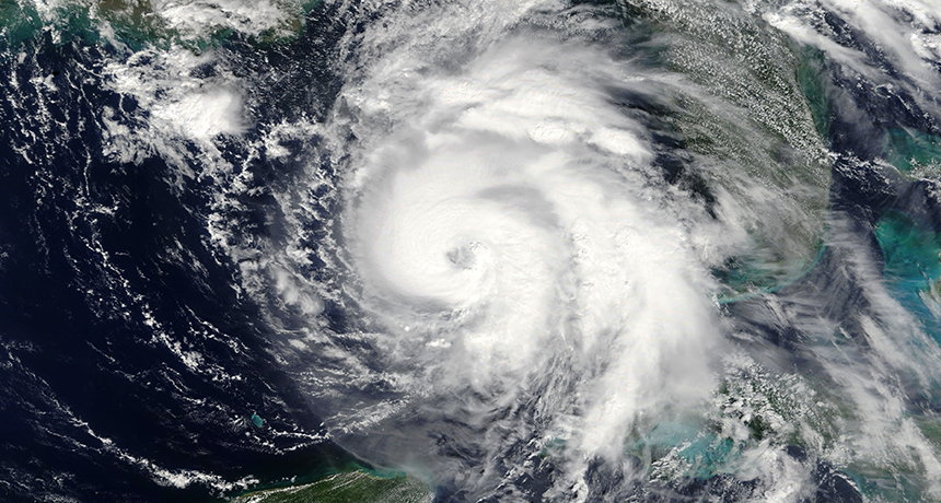
Michael, shown here hours before it made landfall as a Category 4 hurricane, gathered strength from unusually warm Gulf of Mexico waters.
NASA
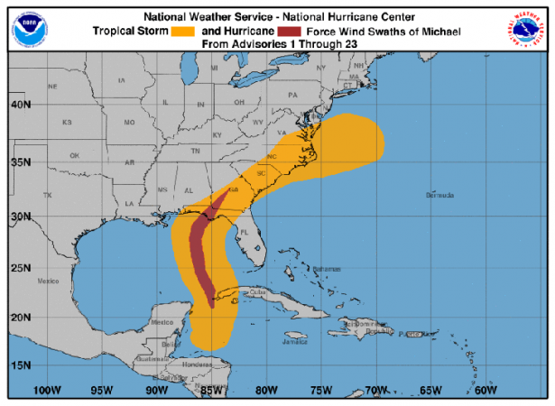
Call Hurricane Michael the October surprise. This fast-moving cyclone strengthened unusually quickly — in less than two days. Then, it slammed into the Florida panhandle on October 10. The panhandle is a curving coastline surrounding the northeastern Gulf of Mexico. As Michael swiftly blew north into Georgia, it lost little of its oomph.
Key to its damage, especially in Florida, were the ferocious winds in its eyewall. That’s the wall of super-strong winds that surround the calm heart at the center of a hurricane.
The storm made landfall with sustained winds of about 250 kilometers per hour (155 miles per hour). That speed falls just shy of a category 5 storm. Were it just 2 kph (2 mph) faster, it would have qualified as a Cat 5 cyclone. Michael also came in as the strongest storm ever to hit the region. That’s according to the National Hurricane Center, or NHC, in Miami, Fla.
Warm ocean waters fuel a hurricane. They do this by feeding it heat and moisture. The drier air over land, by contrast, helps to strip power from a storm. So hurricanes nearing the Florida panhandle tend to weaken as they pull in the drier air from land.
But not with Michael. The Gulf’s waters have been about 1 degree to 2 degrees Celsius (1.8 to 3.6 degrees Fahrenheit) warmer than normal for this time of year. Air over the eastern United States has also been extra moist. Both helped supercharge the storm.
Scientists had expected some wind conditions to weaken Michael. In fact, this storm strengthened steadily until it made landfall. And that, the NHC notes, “defies traditional logic.” As it approached the coast, the eyewall was bringing devastation to the path it would cover. People directly in its path who didn’t evacuate tweeted news of the storm damage. Some described homes being reduced to rubble.

But regions well outside the eyewall could feel “hurricane-force gusts” of 115.9 kph (72 mph) or more, noted NHC Director Ken Graham. He was speaking in an October 10 Facebook Live update on the storm. Michael weakened only to a category 3 before hurtling into Georgia.
It is not possible to “attribute” the formation of any one storm to Earth’s warming climate. However, scientists have been predicting that warming oceans would lead to more intense hurricanes.
Computer analyses have been turning up support for that in their review of recent storms. Known as attribution studies, they analyze data from storms against conditions recorded through history. They now have begun finding evidence that very warm waters in the tropical Atlantic, last year, helped to fuel that hurricane season’s big three: Harvey, Irma and Maria. For instance, an unusually warm Gulf of Mexico helped Harvey strengthen fast. It powered up from a mere tropical storm to a Cat 4 cyclone within about 30 hours.
And such rapid strengthening of cyclones didn’t happen last year only. Just last month, Florence slammed into the Carolinas. It too rapidly intensified due to warmer than normal sea-surface temperatures. Even as this storm was underway, scientists were already reporting evidence that those warm waters appeared responsible for upping the storm’s girth and rain totals.


