ICESat-2 measures ice and more from space
This new eye in the sky can detect changes in glaciers, ice sheets, forests and some clear lakes

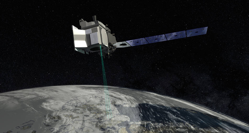
ICESat-2’s bright green lasers can monitor Earth’s glaciers and ice sheets by detecting changes in their heights.
NASA
By Sid Perkins
WASHINGTON, D.C. — On September 15, 2018, NASA launched the Ice, Cloud and land Elevation Satellite-2. Most will call it ICESat-2, for short. As its name suggests, this orbiting probe will be checking out Earth’s frozen water. But it will track more than that.
Orbiting Earth at an altitude of about 500 kilometers (310 miles), it zips through space at some 25,200 kilometers (15,660 miles) per hour. At this speed, the satellite completes one orbit every 95 minutes or so. ICESat-2 moves over almost 1,400 unique paths on the ground, collecting data all along the way. It takes 91 days to complete them all. At that point, the cycle starts again.
Thomas Neumann works at NASA Goddard Space Flight Center in Greenbelt, Md. As a cryospheric (Kry-oh-SFEER-ik) scientist, he studies ice sheets and glaciers. He described ICESat-2 and its mission, here, in December 2018. He spoke at the fall meeting of the American Geophysical Union in Washington, D.C.
Unlike many NASA probes, ICESat-2 carries only one instrument — a laser altimeter (Al-TIM-eh-tur). It shoots green laser beams down at Earth. The device’s telescope collects the light that bounces back and a computer processes those data.
The reflected light allows the system to measure its own altitude, or height, above a surface. ICESat-2’s orbit is designed to be consistent. So, if the altimeter detects a difference from one spot to the next, it means that there’s been a change in the height of Earth’s surface. And if there’s a change in altitude from one ICESat-2 visit to the next, that will mean the surface has moved up or down over the past 91 days.
How the altimeter works

ICESat-2 fires its laser 10,000 times each second. Before a pulse leaves the satellite, each blip of green light gets split into six separate beams. (That means ICESat-2 is making a whopping 60,000 measurements every second!) Each light pulse contains some 300 trillion photons. Yet only a dozen or so of these will make it back to the altimeter’s sensors. Even so, says Neumann, there is a lot of information that can be gleaned from those few photons that make it back.
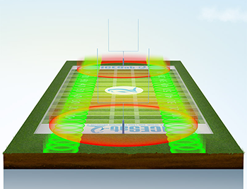
By the time the beams reach the ground, they will have spread out. Each will now make a circle some 17 meters (56 feet) across. In the instant between two laser pulses, the craft will have moved about 70 centimeters (2.3 feet) along its path. This means there will be a large overlap between one laser measurement and the next.
At polar sites, these data can be used to estimate the thickness of sea ice. Here’s how: Some photons will bounce off of floating ice. Others, meanwhile, may bounce off open water nearby. The ones reflected off the surface of the ice travel a slightly shorter path. That’s because the surface of the ice stands a bit higher than the water’s surface. So these photons will return to ICESat-2 a bit more quickly than those bouncing off of the water. Because scientists know exactly how fast light travels, the time difference between the first echoes and the last ones lets researchers calculate the height of the ice above the water.
In recent years, scientists have noted that sea ice in the Arctic has been thinning. Other satellite studies, together with field work, have revealed that many glaciers and ice sheets are thinning, too. ICESat-2 will precisely track these trends.
The altimeter can’t track changes at every spot on Earth, Neumann notes. For instance, it won’t pass closer than about 450 kilometers (280 miles) to the North or South Pole. That means there are some blind spots in its measurements. And even those paths that the satellite does take aren’t wide enough to provide full coverage of lower-latitude sites.
But one big benefit ICESat-2 does offer: This probe will be looking at the same spots again and again. So it can document changes from season to season and from year to year, Neumann says.


What’s happening on land?
ICESat-2 will give scientists the chance to monitor all sorts of terrain, even spots not covered with ice. (If you remember, part of ICESat-2’s full name includes the phrase “land elevation.”) Indeed, photons from the satellite’s altimeter will bounce back to space from anything on Earth’s surface.
That opens up a lot of possibilities, says Lori Magruder. She’s an ICESat-2 team leader who works at the University of Texas in Austin. She outlined a few of these possibilities at the 2018 AGU meeting.
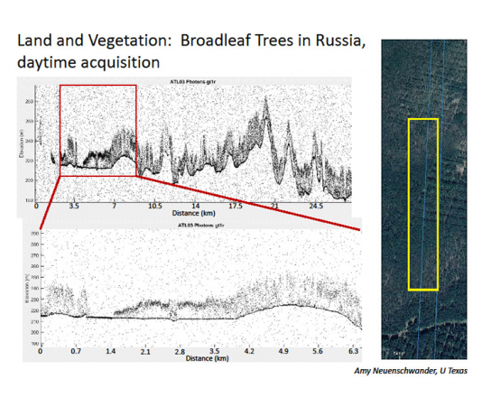
ICESat-2 can monitor Earth’s forests, for instance. Just as its altimeter can measure the height of sea ice, she notes, it can measure the heights of trees. It takes a bit more work than measuring the ice. Why? Some photons traveling back to ICESat-2’s sensors will have bounced back from branches at the top of the tree. Others will have reflected off lower branches. Yet others will have made it all the way back from the forest floor. The time difference between the first photons to return and the last ones let the researchers estimate the heights of the trees within each 17-meter-wide laser spot. Researchers can use that info, along with data gathered by scientists on the ground, to estimate how much carbon has been stored in those forests. The carbon comes from the carbon dioxide (CO2) taken up by the trees. Measuring the trees’ carbon helps climate scientists monitor how planet-warming CO2 forests are removed from the air and storing by those trees.
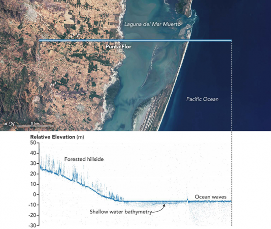
Here’s another neat thing ICESat-2 can do: The laser’s green (532-nanometer wavelength) light can penetrate water. If that water is not cloudy or filled with suspended sediment, that light can reach to depths of 30 meters (98 feet). So ICESat-2 can monitor the depth of lakes and reservoirs. That allows scientists to gauge how much water such reservoirs hold.
ICESat-2’s altimeter also could be used to measure the depths of coastal waters, Magruder believes. Those depths don’t tend to change quickly. Ships can measure them even more accurately. However, she notes, data from ICESat-2 will provide a seamless set of measurements that stretch from coastal waters onto land and be repeated every three months. And that, she suggests, could help in building computer models to better project the heights of future tsunamis or storm surges. Those, she notes, can strike coasts during a hurricane or after a big earthquake at sea.


