Quake risk in some central states rivals California’s
Underground disposal of fluids from oil and gas drilling has been triggering damaging quakes

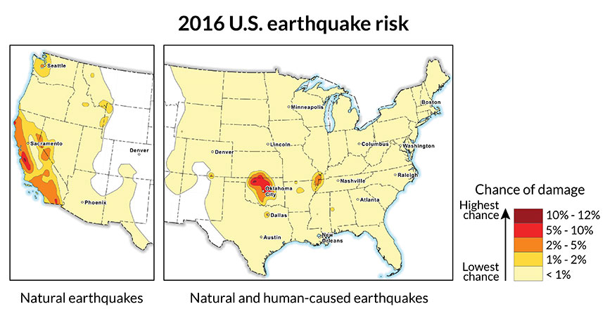
A new hazard map by the U.S. Geological Survey shows that the risk of earthquakes is as great in a few parts of the central United States as in quake-prone California.
USGS
Northern Oklahoma is just as likely to suffer a damaging earthquake within the next year as are the most quake-prone areas of California. The reason: Earthquakes are no longer just a natural hazard. That’s a new finding of the U.S. Geological Survey (USGS). In its 2016 quake-hazards forecast, this agency includes for the first time earthquakes caused by human activity.
It published its new report online March 28.
Unlike California, Oklahoma and other parts of the central United States weren’t always earthquake hotspots. From 1973 to 2008, an average of 24 potentially damaging quakes rattled the central United States each year. Since then, its yearly average has skyrocketed to 318 quakes. Last year, a record-setting 1,010 tremors occurred!
Earthquake scientists now know that this increased earthquake risk stems largely from local oil and gas drilling operations.
That drilling can produce large amounts of waste fluids. Those fluids contain chemicals that can be dangerous to people and the environment. So they must be disposed of safely. Companies often pump the waste fluids into storage wells deep underground. This traps them under layers of rock.
But that also causes fluid pressures underground to rise. Those pressures can disturb cracks in the rock, called faults. Unclamping those faults can trigger earthquakes.
Around 7 million people currently live and work in areas of the central and eastern United States that are vulnerable to earthquakes above a magnitude of roughly 2.7, USGS scientists estimate.
Human-caused quakes aren’t as powerful as natural ones. The strongest human-caused quake in the United States clocked in at magnitude 5.6 in 2011. That’s strong enough to cause minor injuries and to damage buildings and roads. It is not nearly as strong, however, as the 7.8-magnitude quake that struck San Francisco in 1906. Still, the potential for very powerful shakes exists, the scientists warn. The new USGS report should help governments revise building codes to better prepare for the rising quake risks.
Power Words
(for more about Power Words, click here)
earthquake A sudden and sometimes violent shaking of the ground, sometimes causing great destruction, as a result of movements within Earth’s crust or of volcanic action.
fault In geology, a fracture along which there is movement of part of Earth’s lithosphere.
magnitude (in geology) A number used to describe the relative size of an earthquake. It runs from 1 to more than 8 and is calculated by the peak ground motion as recorded by seismographs. There are several magnitude scales. One of the more commonly used ones today is known as the moment magnitude. It’s based on the size of a fault (crack in Earth’s crust), how much the fault slips (moves) during a quake, and the energy force that was required to permit that movement. For each increase in magnitude, an earthquake produces 10 times more ground motion and releases about 32 times more energy. For perspective, a magnitude 8 quake can release energy equivalent to detonating 6 million tons of TNT.
natural gas A mix of gases that developed underground over millions of years (often in association with crude oil). Most natural gas starts out as 50 to 90 percent methane, along with small amounts of heavier hydrocarbons, such as propane and butane.
U.S. Geological Survey, or USGS This is the largest nonmilitary U.S. agency charged with mapping water, Earth and biological resources. It collects information to help monitor the health of ecosystems, natural resources and natural hazards. It also studies the impacts of climate and land-use changes. A part of the U.S. Department of the Interior, USGS is headquartered in Reston, Va.


