Recipe for a hurricane
Predicting how, when, and where major storms will occur can help save lives.
By Emily Sohn
Last August, Charley ripped through Florida. The hurricane tore up trees, wiped out houses, and caused more than $7 billion in damage.
At about the same time, a series of typhoons killed at least 40 people in the Philippines and forced more than a million people to flee. Three weeks later, Hurricane Frances followed Charley’s lead, again pummeling Florida—to the dismay of many people in the state. Then came Ivan and Jeanne. Hurricane Jeanne killed more than 1,000 people in Haiti, before heading for the Bahamas and Florida.
 |
|
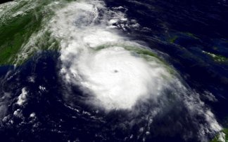
This satellite image shows Hurricane Charley near the time when the storm’s center, or eye, reached the west coast of Florida at Cayo Costa on Aug. 13, 2004.
|
| National Oceanic and Atmospheric Administration |
The onslaughts may have been massive, but they weren’t a surprise.
Every year, major storms cause major problems around the world. There’s nothing people can do to stop the powerful forces of nature. But new techniques are helping scientists to predict how, when, and where the big ones will occur. The more accurately scientists can give warnings, the more likely people are to grab their valuables and flee to safety.
Predictions are improving. “We’ve gotten better over the years, especially the last few years,” says Phil Klotzback. He’s an atmospheric scientist at Colorado State University in Fort Collins.
Storm formation
There’s plenty left to learn, though. Even when scientists can figure out where a storm is headed, winds can change at the last minute, carrying the storm in a new direction.
Charley, for example, was originally headed right for the city of Tampa Bay but ended up hitting the Florida coast further south.
 |
|
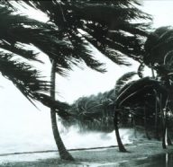
Hurricane-driven waves strike a sea wall.
|
| NOAA Photo Library |
“A little shift can make a big difference,” says meteorologist Eric Blake. He works at the National Hurricane Center in Miami. “Meteorology is both a science and an art.”
The science part depends mostly on computer simulations, or models, and knowledge of the past. Scientists have been collecting data about storms for decades. They’ve noticed patterns that suggest what it takes for a strong storm to form in the first place.
Hurricanes that hit the United States start when a thunderstorm forms off the coast of Africa. Storms also develop over tropical waters in other parts of the world. Most storms end up falling apart on their own, and we never hear about them.
For a hurricane to get organized, “conditions have to be just right,” Klotzbach says.
First, the ocean water needs to be warm enough so that the winds can take up water through evaporation, which rises into the air. As it rises, the vapor cools and turns back into liquid. This process releases heat. The cycle of evaporation and condensation is like an engine that causes winds to swirl and grow. It drives the formation of a hurricane.
If wind speeds inside the swirling mass reach 40 miles per hour, the system is classified as a “tropical storm,” and it gets a name. At 75 miles per hour, it becomes a hurricane. In the western Pacific, hurricanes are known as typhoons.
On average, 60 or 70 storms form off Africa every year, Klotzbach says. About 10 of them get names. There are usually about six hurricanes. Two tend to be very intense, with winds of 115 miles per hour or higher.
Hurricane season lasts from June 1 to Nov. 30. Ninety percent of all hurricanes hit in August, September, and October, Klotzbach says. Half usually happen in September, when conditions are most favorable.
Hurricane tracks
The National Hurricane Center tracks storms as they happen. Observations and data come from people on ships out at sea and from satellites in orbit around Earth. Computers crunch the data for warning signs of a developing storm.
Years of observations have supplied scientists with fairly reliable patterns that help them figure out what’s going to happen next.
 |
|
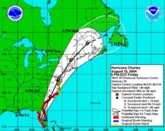
Experts try to predict where a hurricane will go. Here, they show Hurricane Charley’s possible track after the huge storm hit the Florida coast.
|
| NOAA |
In the northern hemisphere, hurricanes spin counterclockwise around a center, called an eye. Tropical trade winds carry these systems across the ocean toward the southeastern United States.
When a big one starts to form, meteorologists begin to watch it closely. Some experts even fly into the eye to get a closer look. As the storm approaches land, meteorologists at the Hurricane Center send out advisories every 6 hours.
 |
|
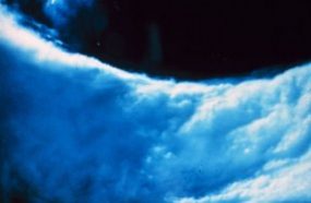
Researchers can fly into the center, or eye, of a hurricane to learn more about the storm. This photo shows part of the wind-driven wall of clouds surrounding the eye, a center spot of calm air.
|
| NOAA |
When they get to land, storms often turn north before cruising east again, back out to sea. But with unpredictable changes in temperature and wind patterns, it doesn’t always work that way.
“Forecasts of the exact track have gotten considerably better over the last 10 years,” Blake says. Still, such predictions are good for only a few hours. And storms are constantly full of surprises.
“Storms can track in all sorts of strange ways,” Klotzbach says. Such quirks keep people glued to their radios and TVs when hurricanes approach land, as they listen for the latest reports on which way a storm is headed.
Future storms
As if that weren’t tricky enough, researchers at Colorado State try to make predictions months ahead of time. Before the start of each hurricane season, they announce how many hurricanes and severe storms they expect will occur in the coming summer and fall.
 |
|
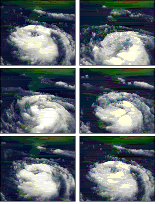
This sequence of satellite images show Hurricane Georges, which struck in 1998.
|
| NASA |
Some years are more active than others. And knowing what to expect is important to lots of people, including emergency managers, insurance companies, and people who live on the coasts. Being prepared can save millions of dollars and lots of lives.
To predict the future, the Colorado State researchers use computer models to look to the past. “Basically, we see what global climate features worked well in forecasting previous years,” Klotzbach says. “We assume the future is going to be like the past.”
For instance, when temperatures at the surface of the Atlantic Ocean are warm in late spring and early summer, the hurricane season tends to be very active. In years that have a weather pattern called El Niño, on the other hand, high winds tend to break storms up, and few hurricanes develop.
Researchers at Colorado State have used such patterns to make predictions for the last 21 years, Klotzbach says. Their predictions are now a lot better than those they made even a few years ago.
Last May, for example, Klotzbach and his team predicted an “above-average” probability of hurricanes hitting the U.S. coast in the coming hurricane season. The researchers said they expected 14 named storms and eight hurricanes.
In fact, August had near-record storm activity, and September was also above average. For now, the researchers expect October to be a little quieter than usual.
Personality
Although there are patterns as to when and where hurricanes occur, every hurricane is different. Each one has its own personality.
 |
|
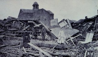
In 1900, a deadly hurricane struck Galveston Island, Texas, destroying homes and killing more than 6,000 people. It was the greatest natural disaster in terms of loss of life in United States history.
|
| NOAA Photo Library |
To acknowledge that variety, every big storm gets its own name. Storms in the Atlantic are named after people. In the Pacific, storms can be named after flowers or take on nicknames. The World Meteorological Organization decides names in advance, and the alphabetical list rotates every 6 years. Names on the list get replaced only if a storm with a particular name is especially severe—killing lots of people or costing loads of money. That way, the name takes its place in history.
Teddy. Sally. Emily. Dennis. The names may sound friendly. But, watch out. Hurricanes are like bullies. Even with a name like Debby or Charley, big storms can turn on you when you least expect it. Knowing what to look for can help you get out before it’s too late.
Going Deeper:
Hurricane Names
All hurricanes are given names. For Atlantic Ocean hurricanes, the World Meteorological Organization has six lists of names, one list per year. The same names are reused every 6 years.
The names may be French, Spanish, or English, one for each letter of the alphabet, except Q, U, and Z. If a hurricane turns out to be especially deadly or costly, its name is retired and a new name is selected to replace it.
Is your name among those in the lists?
| 2002 | 2003 | 2004 | 2005 | 2006 | 2007 |
| Arthur | Ana | Alex | Arlene | Alberto | Andrea |
| Bertha | Bill | Bonnie | Bret | Beryl | Barry |
| Cristobal | Claudette | Charley | Cindy | Chris | Chantal |
| Dolly | Danny | Danielle | Dennis | Debby | Dean |
| Edouard | Erika | Earl | Emily | Ernesto | Erin |
| Fay | Fabian | Frances | Franklin | Florence | Felix |
| Gustav | Grace | Gaston | Gert | Gordon | Gabrielle |
| Hanna | Henri | Hermine | Harvey | Helene | Humberto |
| Isidore | Isabel | Ivan | Irene | Isaac | Ingrid |
| Josephine | Juan | Jeanne | Jose | Joyce | Jerry |
| Kyle | Kate | Karl | Katrina | Kirk | Karen |
| Lili | Larry | Lisa | Lee | Leslie | Lorenzo |
| Marco | Mindy | Matthew | Maria | Michael | Melissa |
| Nana | Nicholas | Nicole | Nate | Nadine | Noel |
| Omar | Odette | Otto | Ophelia | Oscar | Olga |
| Paloma | Peter | Paula | Philippe | Patty | Pablo |
| Rene | Rose | Richard | Rita | Rafael | Rebekah |
| Sally | Sam | Shary | Stan | Sandy | Sebastien |
| Teddy | Teresa | Tomas | Tammy | Tony | Tanya |
| Vicky | Victor | Virginie | Vince | Valerie | Van |
| Wilfred | Wanda | Walter | Wilma | William | Wendy |
The following names have been retired: Agnes, Alicia, Allen, Allison, Andrew, Anita, Audrey, Betsy, Beulah, Bob, Camille, Carla, Carmen, Carol, Celia, Cesar, Cleo, Connie, David, Diana, Diane, Donna, Dora, Edna, Elena, Eloise, Fifi, Flora, Floyd, Fran, Frederic, Gilbert, Gloria, Gracie, Georges, Hazel, Hilda, Hortense, Hugo, Inez, Ione, Iris, Jane, Joan, Keith, Klaus, Luis, Lenny, Marilyn, Michelle, Mitch, Opal, Hattie, Roxanne.
Source: Federal Emergency Management Agency


