Meet the sneaky and surprisingly dangerous squall-line tornado
These destructive, radar-dodging twisters often form at night
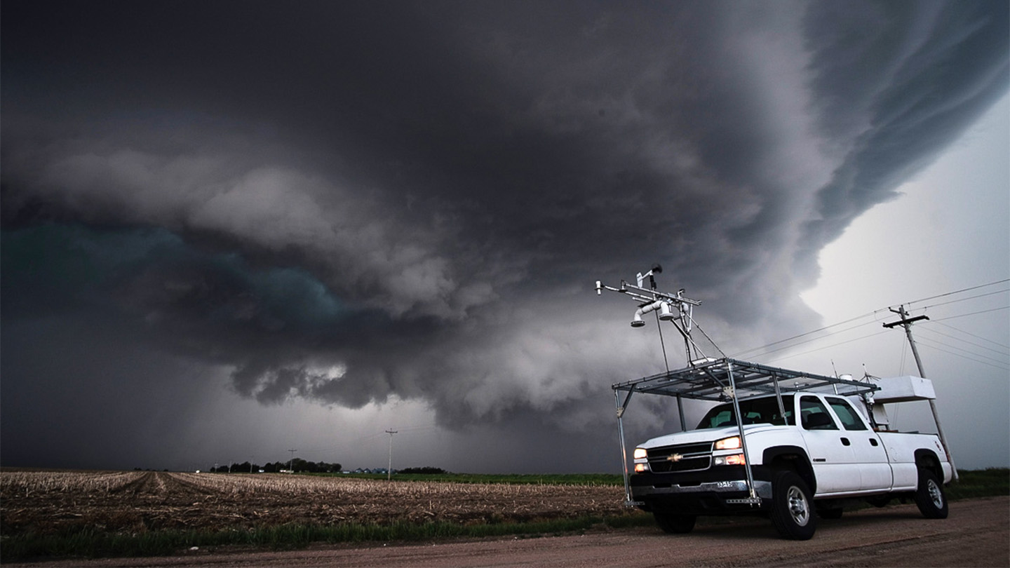
In 2022 and 2023, PERiLS researchers deployed across the southeastern United States used a fleet of instruments to capture a trove of data on squall-line tornadoes. Mobile Mesonet vehicles (shown) took surface measurements of temperature, pressure, humidity, wind and solar radiation.
Michael Coniglio, NOAA NSSL
Meteorologist Thea Sandmael watched the storm close in. It was near enough for her to spot a rotating dome of clouds emerging from the storm’s dark underbelly. By the time the spinning mass was 10 minutes away, Sandmael and her colleagues had packed up their radar equipment and left.
“Just keep going,” she advised her colleague behind the wheel. Her driver was rightly focused on maneuvering their SUV down a remote Alabama road. Evacuating was a good decision, she reflects: “We were sitting on the west side of the road.” And in short order, she recalls, the tornado would touch down “in our exact location.”
Sandmael works for the Cooperative Institute for Severe and High-Impact Weather Research and Operations, or CIWRO. It’s in Norman, Okla. And for her, this wasn’t just another day of chasing tornadoes. That day, she and her crew were after something unusual.
It’s a sneaky type of twister — a squall-line tornado.
The most common tornadoes form in isolated storms called supercells. They’re also the most destructive and well-studied class of twisters. Squall-line tornadoes are different. They develop at the front of long rows of storms. These fronts are known as QLCSs. That’s short for quasi-linear convective systems. Just call them squall lines.
They’re generally less intense than supercell tornadoes, says Karen Kosiba. But, she adds, “that doesn’t mean they’re not dangerous.” An atmospheric scientist, she works at the University of Illinois Urbana-Champaign.
These squall-line tornadoes have a tendency to surprise.
They are ephemeral, or short-lived. That means they can form and die in the minutes between two scans of most radar systems. So they often evade detection. They’re also hard to anticipate. They can emerge suddenly along long rows of storms — ones that can span hundreds of kilometers (100 miles or more).
And compared to supercell tornadoes, squall-line twisters occur more often in the cool season. Especially troubling: They often develop after dark, a time when supercell tornadoes are less common.
Squall-line twisters differ from supercell tornadoes in another way, too. They’re more likely to develop in the southeastern United States. It’s a region that’s especially unlikely to weather these storms well.
Over the last 70 years, the center of tornado activity has shifted in the United States — for supercells and squall lines alike. They used to seem to prefer the Great Plains. Now, many more are spinning up in the Southeast. This region is more densely populated than the Great Plains. It also has a greater share of easily uprooted mobile and manufactured homes.
In this new tornado heartland, a squall-line twister doesn’t need to be super intense to pose a grave risk.
Recognizing the need to reduce that risk, Sandmael, Kosiba and dozens of other researchers have joined forces to launch a field campaign. They’ve named it PERiLS. That’s short for Propagation, Evolution and Rotation in Linear Storms. During the late winter and spring seasons of 2022 and 2023, PERiLS deployed across the Southeast. And its research captured an unprecedented trove of data.
Squall-line tornadoes may be more common and more dangerous than previously thought, those data now reveal. Fortunately, this research also may have turned up clues that could help make these twisters just a bit less sneaky.
A new twist on the tornado recipe
Whipping up a tornado requires three ingredients. First, there must be a source of rotating winds. There also needs to be a lifting mechanism. This will trigger big parcels of air to rise. Finally, there must be something to keep that uplift going.
This may begin with, say, an advancing cold front. It can push from underneath to lift the air ahead of it. What forms is an updraft. To keep that updraft going, air near the ground needs to have some buoyancy. Meteorologists refer to this as instability.
And the secret sauce that gets things spinning? That’s vertical wind shear, or a change in the speed of winds with increasing height. Think of an upright paddle wheel. When higher winds move faster and push harder on the top paddles, the wheel rotates.
Anthony Lyza is an atmospheric scientist with the National Oceanic and Atmospheric Administration, or NOAA. He works at CIWRO. Recent observations, he says, suggest that the three ingredients needed for a tornado can combine in different ways than previously thought, triggering squall-line twisters.
Take instability. It’s often measured as what they call CAPE. That’s short for convective available potential energy. It’s sometimes described as the energy available to fuel a growing storm.
CAPE values of 1,000 joules per kilogram (J/kg) are usually high enough to power strong storms, according to NOAA. But a lot of squall-line twisters actually form “in a low CAPE, high [wind] shear environment,” notes Alexandra Anderson-Frey. She’s an atmospheric scientist at the University of Washington in Seattle.
In March 2022, for instance, PERiLS researchers observed a squall line over Mississippi and Alabama. They measured a CAPE of only about 500 J/kg in this storm. Yet it spun off dozens of tornadoes.
And Lyza has seen squall-line twisters supported by CAPE values only a fifth that high (100 J/kg). Such low-CAPE settings have been little studied in terms of their ability to spin out squall-line twisters, Anderson-Frey says.
At the same time, new technology has been uncovering more squall-line tornadoes. Older Doppler radar technology scans only in the horizontal dimension. Newer dual-polarization radar can scan in both the vertical and horizontal dimensions. Over the last decade, widespread use of the newer technology has increased detection of squall-line twisters, Lyza says.
What this means: Squall-line tornadoes may be more common than researchers had thought. And if true, then it’s a bit less surprising that some low-CAPE storms have been proving so dangerous.
Do you have a science question? We can help!
Submit your question here, and we might answer it an upcoming issue of Science News Explores
Breakneck turns
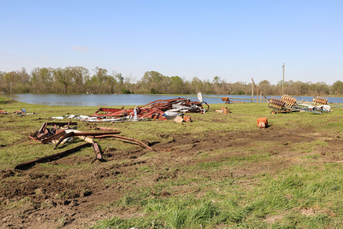
On a calm afternoon in March 2022, Lyza showed up at a rural farm in Noxubee County, Miss. Only a day earlier, a squall-line tornado had torn through the area. Lyza showed up to help assess the damage on behalf of PERiLS.
Right away, something about the scene struck him as odd.
The operational radar had not indicated that the tornado had been all that intense. Yet Lyza observed significant damage to a house on the farm.
“A good chunk of the roof decking was blown off,” Lyza says. “And an entire exterior wall was blown out of the house.” Nearby rested the remains of a machine shed. The storm had uprooted it and ripped it apart, Lyza noted. What he found so surprising: That shed had been anchored to the ground by 5-foot-long concrete pillars.
“We were pretty shocked,” he recalls. “We didn’t necessarily go to Noxubee County thinking we were going to find strong tornado damage.”
And extensive damage wasn’t the only surprise. “We noticed that the tornado came into the property from the southwest” and was heading northeast, Lyza says. Yet a trail of damaged trees seemed to suggest that the twister then veered due east for a couple hundred yards before quickly swerving back toward the northeast.
Tornadoes can and often do change directions. But at high speeds, their turns become wide, just like cars swing wide when rounding a turn at highway speeds. Yet the Noxubee tornado’s track bent sharply — even though it had been advancing at about 100 kilometers per hour (more than 60 miles per hour).
How do they know that? A mobile radar vehicle had been deployed just four kilometers (2.5 miles) to the south. Its beams captured the twister’s odd dance.
Tornadoes inside tornadoes
That radar also found evidence that the tornado’s strange path had been shaped by multiple vortices: There had been tornadoes within a tornado!
“It’s a first that I know of — that anyone around here knows of — in terms of a [squall-line] tornado,” Lyza says.
These sub-tornadoes appeared and disappeared. And they did it quickly. They were so quick that it was hard to follow how they developed from the intermittent radar scans. But “within a single scan, I think the most I was able to confidently identify was four at a time,” Lyza says.
“These individual vortices were actually responsible for most of the damage,” he says. In fact, “the main tornado itself was rather weak.”
Squall-line tornadoes tend to be wider than supercell tornadoes. And that may be because they house so many subvortices, Lyza says. Squall-line tornadoes also tend to be less effective than similarly intense supercell twisters at lofting debris into the sky. Lyza speculates that this could be because their subvortices are so short-lived. “They won’t necessarily have the opportunity to lift debris as high up.”
These subvortices “probably increase the maximum intensity of the tornado,” says Frank Lombardo. He assessed damage at the site with Lyza. A wind engineer, he works at the University of Illinois Urbana-Champaign. And faster wind speeds in a subvortex, he explains, may amp up the wind speeds of its parent twister.
Based on this single case, it’s hard to say whether subvortices are common in squall-line tornadoes. But if they are, “we might have to revisit our tornado-risk calculations,” he adds. “We may have totally underestimated their intensity.”
Improving twister forecasts
Learning that squall-line tornadoes may be more common and stronger than previously thought makes the need to be able to predict them even more urgent. Thankfully, the PERiLS project may have found some much-needed clues.
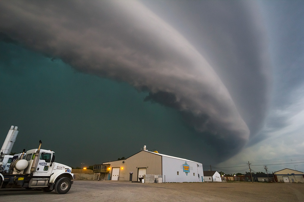
Researchers think that certain wind patterns inside squall lines can help them predict the emergence of twisters. They’re especially interested in gyres of wind called mesovortices (MEH-zoh-VOR-tih-sees). The gyres’ diameter can range from a kilometer to dozens of kilometers.
Mesovortices often form where advancing squall lines bend into the shape of an archer’s bow. For decades, scientists have observed tornadoes at the leading edge of these bows.
We can predict squall lines well, says atmospheric scientist Patrick Skinner of CIWRO — at least, more accurately than we can predict other types of thunderstorms. What’s hard, he says, is forecasting the mesovortices that may be within them.
What’s more, tornadoes only form inside some mesovortices. And researchers don’t know why.
Lidar scans the skies with pencil-thin laser beams. They’ll reflect off dust and other aerosols. These serve as tracers to map the wind. Atmospheric scientist Todd Murphy was part of a PERiLS field campaign that used lidar to monitor the air in the hours before a squall line arrived. Murphy works at the University of Louisiana at Monroe.
“In the vast majority of our cases, the lidar data showed pretty abrupt changes in the wind profile beginning about 90 minutes before the squall line got to the site,” Murphy says. At different heights in the lower atmosphere, the vertical wind shear grew larger. This triggered more rotation in the squall line.
And it wasn’t just the wind shear that changed dramatically, he says. All of the PERiLS key ingredients for tornado formation “can change really rapidly within an hour or two ahead of the arrival of a squall line,” Murphy notes.
Murphy and his coworkers focused on how the atmosphere changes ahead of mesovortices in squall lines. They used data collected by PERiLS. They also looked at 10 years’ worth of radar data gathered by the National Weather Service, the Federal Aviation Administration and the U.S. Air Force.
Their analysis focused on wind velocities at different levels in the air ahead of mesovortices that formed tornadoes. And they compared those to wind speeds in storms that remained free of twisters.
There appeared to be slightly more wind shear ahead of tornado-spawning mesovortices, Murphy now reports. More importantly, there also was more rotation. And that was especially true ahead of squall lines that generated at least five twisters.
Concludes Murphy, these data suggest that certain wind structures may be lining up ahead of the mesovortices that form tornadoes.
Updrafts of air continually form and dissipate along the entire length of a squall line. Mesovortices form within those updrafts. When an updraft meets and becomes aligned with air circulating near the ground, the updraft may stretch the circulation upward. That stretching can narrow the circulation’s diameter, like dough that is stretched thin. And this narrowing can speed up the spin.
“We call it the ice-skater effect,” Murphy says. He’s referring to the famous example of a skater spinning faster when both arms pull in close to the body. “If you stretch that rotation,” he explains, “it causes the radius to get smaller — but the rotation strengthens.”
If meteorologists are monitoring conditions 60 to 90 minutes ahead of a squall line and the wind profile starts to develop this signature, then they may need to consider issuing warnings, Murphy says.
He hopes that confirmation by other researchers will show this is “a clear-cut operational signature the Weather Service can probably use.” If all goes well, he says, that could happen sometime in the next couple of years.
Meanwhile, other projects that could improve forecasts are also in the works. Skinner at CIWRO in Norman works on NOAA’s Warn-on-Forecast. It’s a project to increase the lead time of forecasts for tornadoes and other types of severe weather. He’s planning to use PERiLS data to determine how much resolution current computer models of weather need to accurately portray mesovortices in squall lines.
Those weather models will need to get vastly better, he says. Until then, they can’t predict tornado-spawning mesovortices as well as they can predict supercell tornadoes. But eventually, Murphy says, “I think we’ll get there.”


