Tides may regularly swamp many U.S. cities
As sea levels climb, even Washington, D.C., could see more frequent and more widespread flooding at high tide

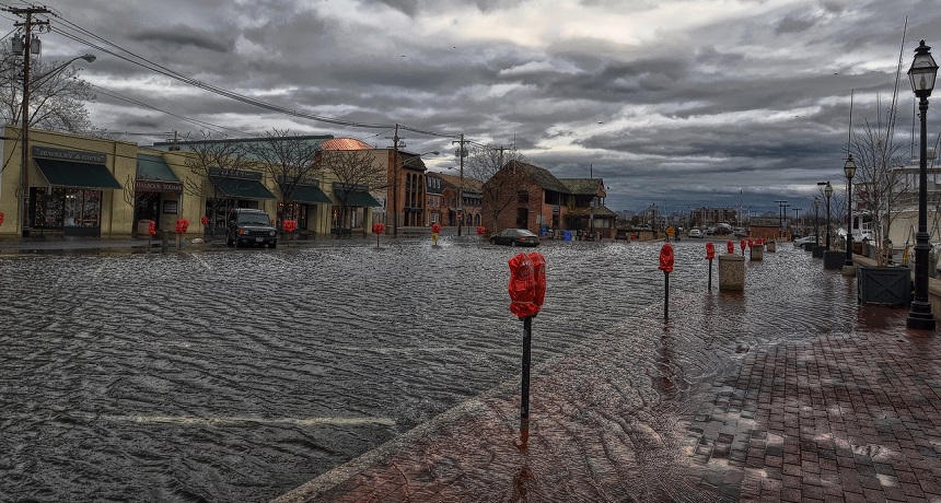
Floodwaters cover a portion of downtown Annapolis, Md., on Dec. 21, 2012. A new report forecasts such coastal flooding will become more common, and affect more regions, as sea levels rise.
Amy McGovern/Flickr
By Sid Perkins
Strong storms and high winds sometimes bring floods to coastal areas. But more and more often, cities and towns along the U.S. East Coast are flooding even in calm, sunny weather.
Among them: Maryland’s capital — Annapolis, home to the U.S. Naval Academy. Tourists there must sometimes wade through water flooding downtown streets surrounding the harbor. From time to time, water covers roads in Atlantic City, N.J. Even the yards and basements of coastal homes near New York City sometimes flood.
All are suffering from a simple evolving trend — normal high tides stacked atop an ever-rising sea level.
Sea level has climbed, on average, about 20 centimeters (8 inches) over the past 135 years. And a sharp increase in tidal flooding is one of the more visible impacts affecting many coastal areas, notes William Sweet. He’s an oceanographer with the National Oceanic and Atmospheric Administration, or NOAA, in Silver Spring, Md.
He and his co-workers recently analyzed data from 45 tide gauges along U.S. coasts. These sensors record the ever-changing heights of tides as they rise and fall. From these data, Sweet’s team tallied the number of “nuisance floods” in various coastal cities. These floods, Sweet explains, typically occur when water level is about 30 centimeters (1 foot) above the historic level of the highest high tides. In June 2014, the team reported finding a growing rise in these flooding events.
|
Data from a Union of Concerned Scientists analysis of 52 U.S. tide gauges stretching from Maine to Texas (charted here) shows that most areas being tracked will experience far more tidal flooding—and more severe floods—in coming decades. Indeed, as sea levels continue to rise over the next 30 years, UCS concludes that frequent tidal flooding may render some coastal areas unusable. UCS |
Take Charleston, S.C. In the seven-year span from 1957 through 1963, the city experienced nuisance floods an average of 4.6 days per year. But over the seven years from 2007 through 2013, the incidence of nuisance floods had jumped five-fold. It now averages 23.3 days per year.
Annapolis saw an even bigger increase. From 1957 to 1963, nuisance floods hit that city roughly 3.8 days per year. From 2007 to 2013, the yearly average was 10 times higher — a whopping 39.3 days.
And this trend is growing. Over the next few decades, climate change is poised to drive sea levels even higher, Sweet says. So today’s flooding problems promise to become only more widespread and more frequent. Sooner or later, says Sweet, nuisance floods “are something that all coastal communities are going to have to deal with.”
More flooding and more costs
Last October, a second group offered a similarly troubling estimate of future flooding. It was published by the Union of Concerned Scientists (UCS). It’s a research group that focuses on energy and environment issues, based in Cambridge, Mass. Researchers there used data gathered by many of the tide gauges that Sweet and his team used, plus others. The UCS analysis suggests that 30 years from now, some coastal areas will experience nuisance floods three or more times as often as they do today. And areas that don’t have floods now may start seeing them by then.
“These floods are not life-threatening,” observes Erika Spanger-Siegfried. She is a data analyst at UCS and a co-author of the new report. Still, these floods “are disruptive,” she notes. What’s more, she warns, “There’s a limit to the number [of flood events] that an area can tolerate.” And one reason: Such disruptions can be very costly.
Sooner or later, nuisance floods “are something that all coastal communities are going to have to deal with.” — William Sweet, NOAA
In the short term, for instance, even minor floods can keep customers from reaching a business. They also can drive away tourists. Over time, repeated flooding will damage roads, bridges and sewage-treatment systems, just to name some types of expensive structures that are vulnerable.
Nuisance flooding “impacts daily life and demands that you adapt to it,” says Rob Thieler. He’s a coastal geologist with the U.S. Geological Survey in Woods Hole, Mass. Studies that call attention to the increasing frequency and extent of nuisance flooding do a great job of making sea-level rise real rather than imaginary, he notes.
Get ready
Sea level is rising for two main reasons. Both relate to climate change. To start, as global temperatures have been rising, ice sheets and glaciers worldwide have, on average, tended to melt faster than they’re growing. The resulting meltwater has been flowing downhill into the oceans. Secondly, the oceans are growing warmer. And water expands as it warms.
Scientists disagree about how much our planet will warm in coming years. That means there are a range of estimates for how much and how quickly sea level will rise. For their new report, Spanger-Siegfried and her co-authors picked a mid-range estimate to use in their calculations. According to that scenario, sea level will rise, on average, about 12.7 centimeters (5 inches) by 2030. Fifteen years later, global average sea level could be around 28 centimeters (11 in.) higher than it is today.
But the water won’t rise equally everywhere. In some coastal areas, the steady upward creep of sea level will seem to rise faster. That’s because some coastal areas are sinking. The scientific term for this is subsidence.
To take into account that ground sinking, the team used data from other researchers that had collected tide-gauge data. Those measurements had been gathered in 52 spots along the coasts of the Atlantic Ocean and Gulf of Mexico between 1959 and 2008. Overall, sea level at those 52 locations by 2045 will rise between 22.9 and 50.8 centimeters (9 to 20 in.), Spanger-Siegfried and her team now project.
“Several decades ago, flooding at high tide was simply not a problem,” says Melanie Fitzpatrick. She’s a climate scientist at UCS. She’s also a co-author of the new report. But these days, she notes, flooding at high tide has become common.

Tides are caused by the gravitational pulls of the moon and the sun on the ocean’s water. Twice each day, most coastal sites experience a high and a low tide. But high tides don’t always rise to the same height. The biggest occur on days near the new and full phases of the moon. That’s when the sun, moon and Earth are most closely aligned.
Eight of the 52 communities that the UCS team studied already experience more than two dozen tidal floods each year. (That’s about one every two weeks, on average.) Within 15 years, if sea levels rise as much as the team expects, 30 of the locales — almost six in every 10 — will see tidal flooding at least twice a month. A handful of sites will see 100 or more high-tide floods per year. That comes to roughly two nuisance floods per week!
Thirty years from now, tidal flooding will be widespread, both new studies predict. Fully half of the cities and towns studied (all but one of them located on the Atlantic coast) will average 100 tidal floods per year. Worse, nine of the locales — including Washington, D.C., Wilmington, N.C., and Atlantic City, N.J. — will see a whopping 240 or more tidal floods per year. That comes, on average, to almost 5 floods a week!
Adapt or retreat
There’s no way around it, coastal locations will experience more flooding with each passing year. So, what can these areas do to cope? It turns out that there are many things. Unfortunately, as Spanger-Siegfried and her co-authors describe in their new report, almost all are quite costly. What’s more, some of the proposed solutions may not even work. And where they do, they may stop working after only a few years.
Charleston, for example, is spending hundreds of millions of dollars to improve drainage along its Market Street. It’s in the city’s historic district, which attracts many tourists. The city also is building a multimillion-dollar seawall. City officials are banking that it will help protect against future high tides. But seawalls also can prevent rainwater from draining out of the city. Such a solution, therefore, might simply trade one type of flooding for another.
New York City has begun work on a $23 million project to improve drainage along three major streets in its Broad Channel neighborhood. That community sits near Jamaica Bay, in the borough of Queens. This area was heavily damaged by Hurricane Sandy. But parts of the neighborhood are prone to flood even in sunny weather.
Some streets there flood often, sometimes twice a month or more. And when that happens, residents have to move their cars to higher ground to avoid saltwater damage. But the new project hopes to fix Broad Channel’s water woes. Construction workers will install a new sewer system. It will include a special drainage system to carry water to the nearby bay. Engineers also will raise the streets, so they flood less often.
“Sea-level rise is like a slow-motion storm surge, except that it doesn’t go away.” — Paul Wolff, Tybee Island councilman
Tybee Island is a small community on a low island near Savannah, Ga. Tybee is spending about $450,000 over three years to protect its water-treatment plant, says Paul Wolff. He’s a local city councilman. He talked about what his city is doing to combat rising sea level during a press conference organized by UCS on October 8. Tybee will raise pumps at the plant, as well as the electronic equipment needed to control those pumps. This should better protect the devices from floods, he said. Engineers also are adding special valves in the pipes that carry treated water to the sea. Those valves will keep seawater from flowing backward during flood events so that they no longer can enter pipes to the treatment plant.
Other plans for Tybee Island include raising roads and bridges, and maybe even lifting houses onto stilts, says Wolff. Now is the time to make these investments, he says. After all, he adds, it’s clear the water is coming: “Sea-level rise is like a slow-motion storm surge, except that it doesn’t go away.”
Many other cities and towns are considering equally drastic solutions to address their own problems. In some places, engineers are considering large gates to help hold the highest floods at bay. In other areas, cities are building large pools to hold water during tidal floods. Such pools would decrease flooding by temporarily storing rainwater runoff during and after large storms. (That also would prevent water — and any pollutants it picks up as it travels over streets and the ground — from entering rivers and other drinking-water sources.)
Eventually, of course, rising seas will likely overcome all short term projects designed to protect coastal areas. Indeed, scientists estimate that by 2100, sea levels will rise anywhere between 45 centimeters and 1.92 meters (18 in. and 6.3 feet). While many researchers look for ways to slow climate change, no one yet has come up with a solution to the worst of the flooding expected to accompany it.
Power Words
(for more about Power Words, click here)
average (in science) A term for the arithmetic mean, which is the sum of a group of numbers that is then divided by the size of the group.
climate The weather conditions prevailing in an area in general or over a long period.
climate change Long-term, significant change in the climate of Earth. It can happen naturally or in response to human activities, including the burning of fossil fuels and clearing of forests.
engineer A person who uses science to solve problems. As a verb, to engineer means to design a device, material or process that will solve some problem or unmet need.
glacier A slow-moving river of ice hundreds or thousands of meters deep. Glaciers are found in mountain valleys and also form parts of ice sheets.
gravitational Having to do with gravity, the force that attracts anything with mass, or bulk, toward any other thing with mass. The more mass that something has, the greater its gravity.
meltwater The water that comes from melting ice. The quantities can be large and show up quickly when it comes from melting glaciers, ice sheets and snow-capped mountains.
National Oceanographic and Atmospheric Administration, or NOAA A science agency of the U.S. Department of Commerce. Initially established in 1807 under another name (The Survey of the Coast), this agency focuses on understanding and preserving ocean resources, including fisheries, protecting marine mammals (from seals to whales), studying the seafloor and probing the upper atmosphere.
runoff The water that runs off of land into rivers, lakes and the seas. As that water travels over land, it picks up bits of soil and chemicals that it will later deposit as pollutants in the water.
scenario An imagined situation of how events or conditions might play out.
sea level The overall level of the ocean over the entire globe when all tides and other short-term changes are averaged out.
seawall A sort of coastal defense against winds and waves. Seawalls typically protect residential, business or recreational areas by reflecting the energy of waves, thereby reducing erosion that could eat away at a shoreline.
sewage Wastes — primarily urine and feces — that are mixed with water and flushed away from homes through a system of pipes for disposal in the environment (sometimes after being treated in a big water-treatment plant).
storm surge A storm-generated rise in water above normal tidal level. In most cases, the largest cause of storm surge is strong onshore winds in a hurricane or tropical storm.
subsidence A downward motion. In geology, subsidence is the downward motion of Earth’s surface. Many coastal areas are subsiding, especially where groundwater has been pumped out from beneath the surface.
tides The alternate rising and falling of the sea, usually twice in each lunar day at a particular place, due to the attraction of the moon and sun.
U.S. Geological Survey, or USGS This is the largest nonmilitary U.S. agency charged with mapping water, Earth and biological resources. It collects information to help monitor the health of ecosystems, natural resources and natural hazards. It also studies the impacts of climate and land-use changes. A part of the U.S. Department of the Interior, USGS is headquartered in Reston, Va.
valve Something that can reduce or shut off the flow of some gas or liquid through a pipe or other passageway. Some specialized valves may allow a liquid or gas to flow in one direction only.
Word Find (click here to enlarge for printing)


