Uplifting Antarctic shores point to accelerating loss of glaciers
Thwaites and Pine Island glaciers appear to be shrinking their fastest in 5,500 years

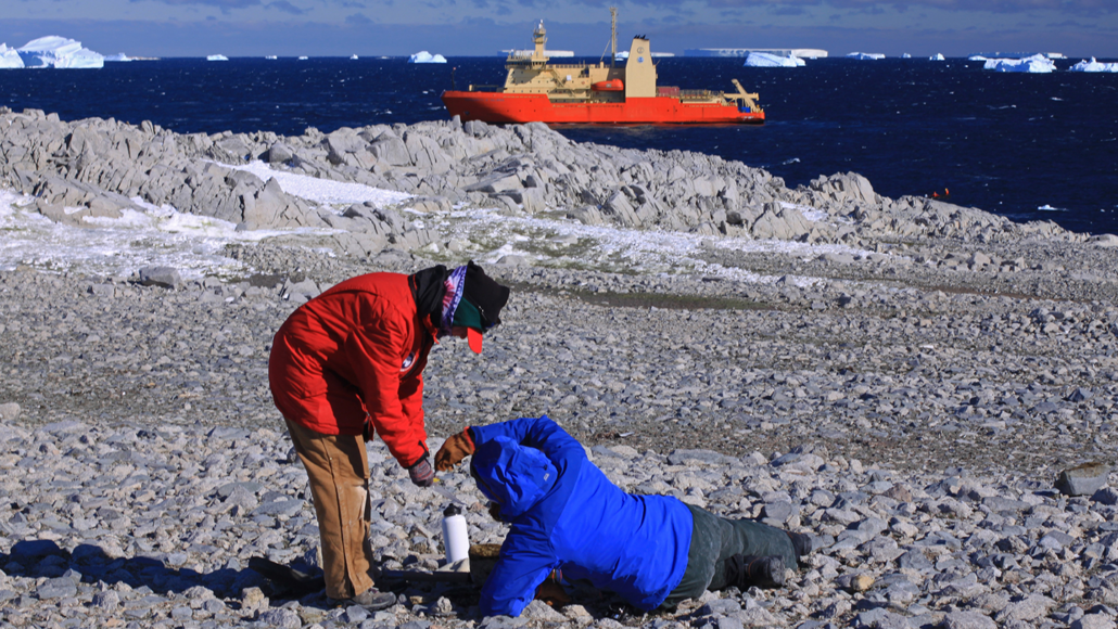
Scott Braddock and Meghan Spoth, PhD students at the University of Maine, collect old shells and penguin bones from an ancient raised shoreline. It sits on an island near Antarctica’s Pine Island Glacier. In the background is the R/V Nathaniel B. Palmer, a U.S. research icebreaker that carried these researchers to the remote area.
James Kirkham
By Douglas Fox
Ice is disappearing more quickly on Antarctica’s Pine Island and Thwaites glaciers than at any time in the last few thousand years. Scientists came to this conclusion after reviewing ancient penguin bones and limpet shells at these sites. The data point to rapidly uplifting ground levels — a sign of ice loss.
The news is disturbing because of the role these masses of ice play. Thwaites, for instance, has been nicknamed the “Doomsday Glacier” because of how much sea levels could rise as it melts.
The Thwaites and Pine Island glaciers are two of Antarctica’s fastest-shrinking ones. Scientists now worry that they not only are unstable but also could undergo a runaway retreat. The researchers looked at old bones and shells to reconstruct the history of the glaciers. They wanted to know if these glaciers had ever been this small before.
“If the ice has been smaller in the past,” then conditions today might suggest “we’re not necessarily in runaway retreat,” explains Brenda Hall. She’s a glacial geologist at the University of Maine in Orono. Alas, she says, the new finding “doesn’t give us any comfort. We can’t refute the hypothesis.” That said, this study also does not yet prove a runaway retreat has begun.
Her team described its findings June 9 in Nature Geoscience.
Melting ice allowed the land to rise
Pine Island and Thwaites glaciers sit in a broad ocean basin. It’s shaped like a bowl, deeper toward the middle. This makes the ice vulnerable to warm currents of dense, salty water that hug the ocean floor. Scientists have worried that as the glaciers retreat farther inland, their melting could become unstoppable. This ice loss could play out over centuries. If it happens, it could end up raising sea levels by roughly a meter (3.3 feet).
To understand how the glaciers have changed over thousands of years, the researchers turned to old penguin bones and seashells. Scott Braddock had collected them during a research cruise on a U.S. icebreaker. He’s a glacial geologist in Hall’s lab.

One afternoon in 2019, Braddock clambered from the icebreaker to a bobbing inflatable boat. He landed on the barren shores of Lindsey 1. It’s one of a dozen or more rocky islands that sit roughly 100 kilometers (62 miles) from where the Pine Island Glacier meets the ocean. As Braddock climbed the slope, his boots slipped over rocks covered in penguin guano. Dingy white feathers also dotted the rocks.
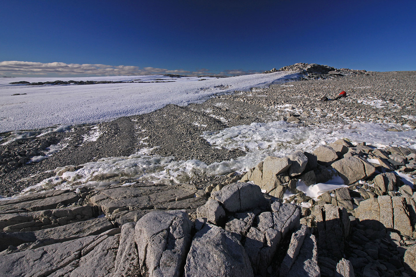
Then, he came upon a series of ridges. Storm waves had piled their rocks and pebbles up thousands of years earlier. These ridges marked ancient shorelines.
As the last ice age was ending some 12,000 years ago, this island would have been entirely submerged under the ocean. But over time, nearby glaciers shed billions of tons of ice. Losing all that weight allowed Earth’s crust to spring up. It was like the rebounding of mattress springs after a heavy person gets out of bed in the morning. That upward thrust of the Earth pushed the top of Lindsey 1 and other nearby islands out of the water. Not by a lot. At least not at first. They rose only a few millimeters (maybe a tenth of an inch) each year.
As Lindsey 1 rose, a series of new shorelines formed along the island’s edge. Over time each new shoreline became elevated, creating yet another. The older shorelines eventually found themselves farther from the reach of the waves.
How much the land moved upward depended on how much ice the nearby glaciers lost. The ages and heights of those former shorelines told the researchers how quickly the islands had risen. This, in turn, let them calculate how quickly the Pine Island and Thwaites glaciers had retreated — and whether either had ever been smaller than it is today.

Telltale clues to glacier retreats
Key to these analyses were the ancient cone-shaped limpet shells and marble-sized fragments of penguin bones that Braddock mined from the pebbly ridges. The debris he retrieved had been left long ago, when the shorelines formed.
Back in Maine, Braddock and others used radiocarbon dating to estimate the ages of those shells and bones. This let the researchers date nearly two dozen shorelines, spread across several nearby islands.
The oldest and highest beach formed 5,500 years ago. From back then until the last few decades, the islands were rising at a steady rate of about 3.5 millimeters (0.14 inch) per year. Then things changed. The ground around Pine Island and Thwaites started to climb much more quickly in recent decades — by 20 to 40 millimeters (0.8 to 1.6 inches) per year. That suggests the rate of ice loss from nearby glaciers has skyrocketed. And the likely cause, they note, is the rapid onset of global warming.
“We’re going into unknown territory,” Braddock says. “We don’t have an analog to compare what’s going on today with what happened in the past.”
Slawek Tulaczyk is a glaciologist at the University of California, Santa Cruz. He sees the newly dated shorelines as “an important piece of information.” But he cautions against making too much of the findings just yet. Yes, these islands are 100 kilometers (62 miles) from the Pine Island and Thwaites glaciers. But they also are less than 50 kilometers (31 miles) from several smaller glaciers. Changes in these closer glaciers, he says, might have masked what was happening at Pine Island and Thwaites long ago.
He still suspects that Pine Island and Thwaites might have retreated to a smaller size — and then grown back to their current size. If this happened, the retreat and regrowth would have been small, he says. Maybe only a few dozen kilometers (perhaps 10 to 30 miles). When it comes to proving whether or not this happened, Tulaczyk says, “I don’t think this study settles it.”


