Wacky winter dumps snow on every single U.S. state
A slowing jet stream may explain the recent cold and snow that surprised even Florida
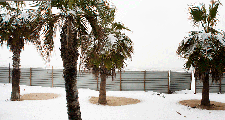
In regions where palm trees grow, one doesn’t expect to see snow. But it can happen, and did last week in parts of the southern United States.
ALEVIGA/iStockphoto
Slushy roads. Ice-topped power lines. Droopy branches sagging beneath the weight of accumulated snow. It sounds like something straight out of a New England winter. In fact, this was the scene right after New Year’s in Florida. And that shouldn’t be, right?
The ocean surrounds this so-called Sunshine State on three sides. That water is as warm as a bathtub’s. This balmy seawater heats the atmosphere all around it. The result? Florida simply doesn’t get that cold. It normally doesn’t, anyway.
That’s why any snow in Florida is rare.
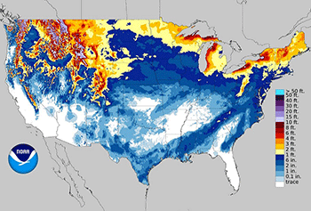
But this U.S. winter is not typical.
By year-end, every U.S. state had recorded snow in 2017. Snowfall in Hawaii? Yep. It has mountains whose high elevations poke into the cold upper atmosphere. Texas? You bet. That was back on December 8. So what’s been behind all of this recent wacky winter weather?
The jet stream is a river of air in the upper atmosphere. It races from regions of warmth to those that are cold. It’s the atmosphere’s way of balancing temperature differences. Sometimes, when this river of air snakes too far south, it can drag cold air with it. That’s how a chunk of Arctic air managed to sneak all the way down to the Gulf Coast.
In early December, the jet stream brought an exceptionally vigorous surge of cold air to the Deep South and northern Gulf of Mexico. In the first week and a half of December, this blasted many normally warm states — ones that tourists typically flee to in hopes of escaping cold northern winters.
Corpus Christi is one of the southernmost cities in Texas. It saw snow for the first time since Christmas 2004. This past December it picked up 2.54 centimeters (an inch) of the fluffy white stuff. That number doesn’t tell the whole story, however. That total is what the “official” National Weather Service observation station recorded. But that office is in town. Just a few miles northwest, a full 12.7 centimeters (5 inches) of snow fell. If that had instead blanketed Corpus Christi, that town would have set an all-time record!
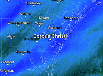
It’s challenging to see any lightning during a snowstorm. But you can detect when it’s near by the muffled thunder that may rumble through dense clouds. This thundersnow occurred on the west side of Corpus Christi. That’s where several heavy snow bands formed along the cold front. Three bolts of lightning even struck the ground!
December’s snow made it all the way down to the Mexican border. It created a vista that many residents had never seen before. After all, you don’t usually see snow falling in the midst of palm trees. Ironically, Corpus Christi had by that time this winter picked up more of the frozen white stuff than had so far hit the traditionally snowy cities of Boston, Chicago, Minneapolis, Detroit and Denver.
As this storm system raced east, snowflakes continued to fly. They fell on Arkansas, Louisiana, Mississippi, Alabama and Florida. Farther north in Georgia, the accumulation was more impressive. Many overachieving locations picked up 15.24 centimeters (half a foot). Most meteorologists chalked it up to a freak event. Surely that wouldn’t happen again anytime soon, right?
Wrong!
Another band of heavy snow materialized near New Orleans, La., on January 2, 2018. It trekked into northern Florida. The National Weather Service office there, in Tallahassee, announced winter storm warnings for much of the area. This weather system carried snow and freezing rain all the way up the Atlantic coastline. In New England, it became a weather “bomb.” That means it intensified extremely quickly. Meteorologists described its boost in strength as “explosive.”
Florida’s dusting
The National Weather Service in Tallahassee shared a map showing several communities that picked up 0.64 centimeter (a quarter inch) of ice cover. A widespread dusting of snow to a couple centimeters blanketed much of the Florida panhandle and upper parts of the state’s peninsula. No snow fell farther south, where it was warmer. (Miami, for instance, hasn’t seen snow in nearly 41 years.)
Despite being rare, a Florida snowfall is not unheard of. Irene Sans is a meteorologist at WFTV News in Central Florida. She also serves on the board of the American Meteorological Society. She had predicted Florida’s recent snow, yet still was amazed to see it.
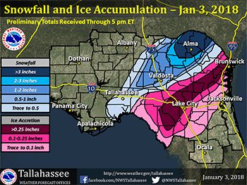
“It is rare, but it can happen,” she says. “Tallahassee received just a little. It wasn’t much, but enough for many to remember for years. Luckily, this little snow quickly melts.” She jokes that “many of us in Florida do not know how to drive in the snow.”
Maureen McCann works for the American Meteorological Society. She also is a television meteorologist and forecasts weather in neighboring Orlando. She recalls that snow has fallen in local warm-weather zones a few times before. “Central Floridians may remember when snow fell in January 1977.” It accompanied a major outbreak of cold temps, she says. Snow didn’t return again until 2010, and that was at an especially inconvenient time. “It occurred the weekend of the Disney Marathon. Runners who anticipated doing the race in warmer weather were unpleasantly surprised.”
What’s more surprising about this winter’s Florida snow, according to McCann, is how warm it’s “supposed” to be in Orlando at this time of year: 71º Fahrenheit (21.7º Celsius).
Farther north, Savannah, Ga., didn’t quite break its all-time record snow total this month — but the region came close. It picked up 3 centimeters (over an inch). This storm also brought something worse: freezing rain. It glazed roads, sidewalks, cars and even trees with ice. Winds to 113 kilometers per hour (70 miles per hour) blew moisture onto most surfaces. It left the entire area a dangerous, if glistening, wonderland.

Savannah’s previous snow record was set 28 years ago. That December 1989 storm dumped 9.1 centimeters (3.6 inches). Jeremy Nelson is the chief meteorologist at WJCL 22 News, which serves coastal Georgia and South Carolina. He was blown away by the snow. He called it “a winter storm that will be remembered for decades.”
“The biggest snow in 28 years hit Savannah on Wednesday, January 3,” he explained. “The storm started with freezing rain before switching over to snow. Most areas picked up two to three inches of snow. Even the beaches along the Atlantic Ocean picked up an inch of snow!”
Charleston, S.C. also came close to setting a new record. Its top snowfall of 15.2 centimeters (6 inches) fell as part of that same 1989 storm. For now, that old record still stands.
A role for climate change?
So why has the South seen so much frozen precipitation lately? The answer may lie with global warming. Though it may seem surprising, the more Earth warms, the more rivers of frigid air may flow south toward the Gulf of Mexico.
And the reason? The Arctic is warming significantly faster than the rest of the planet. That concept is widely accepted by climatologists. It also appears dramatically in data being collected by NASA satellites and other weather-monitoring instruments used by the National Oceanic and Atmospheric Administration. As northern polar regions warm, the temperature contrast between them and temperate zones — such as the continental United States — diminishes. One result is that the jet stream slows down.
How could a slowing jet stream mean more cold air flowing south? Researchers have recently found some clues.
The jet stream’s speed was not the major issue in the past few weeks’ weather. The recent wacky events relate instead to the amplitude of the jet stream. That’s a fancy word for its waviness.
Jennifer Francis is an atmospheric scientist at the Institute of Marine and Coastal Sciences. It’s at Rutgers University in New Brunswick, N.J. She teamed up with Stephen Vavrus at the Center for Climatic Research. That’s at the University of Wisconsin in Madison. Together they were able to relate a slowing jet stream to a wavier jet stream. To do this, they used archived weather maps. Then they tracked how wavy the jet stream was each day over a period of four decades.
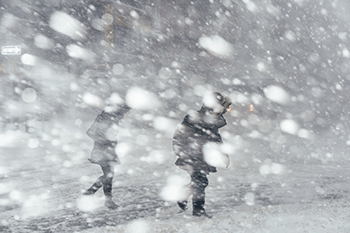
As the climate continues to warm, they argue, the jet stream will only become wavier. When a jet stream slows, it will also tend to meander more. Then it gets wavy and wonky. And that means a normally northerly flowing stream of cold air might detour into the South, dumping unexpected frozen precipitation along the way.
The frequency of so-called “high amplitude days” in the United States — when the jet stream is extra wavy — has spiked by more than 20 percent in the winter. That’s compared to the average prior to 1979. Actually, the most dramatic spike in wavy days has been showing up in the fall, Francis and Vavrus reported a few years back. This is “when sea-ice loss and increased atmospheric water vapor augment Arctic warming.”
When the jet stream gets wavy, it’s easier for pockets of cold Canadian air to slosh southward. That cold air piles up in the troughs of jet stream waves. Therefore, a wavier pattern can yield sporadic bursts of cold air, even in the Deep South.
As oceans warm, the amount of water vapor in the atmosphere will only rise. And that will feed more moisture into these Arctic outbreaks that now can turn into snow.
Some people have claimed that the recent episodes of snow in weird locations disproves global warming. In fact, the contrary is true. These wacky weather patterns may be a seemingly strange symptom of climate change. As the world continues to warm, Francis warns, we’re going to have to expect the unexpected. Get ready, she says: “An increase in extreme weather events” is in store.


